Wednesday, 7 October 2026

Lunar Grounding Challenge

2 min read

Preparations for Next Moonwalk Simulations Underway (and Underwater)

Artist’s rendering of the lunar South Pole region. Glowing points of light scattered across the lunar surface represent surface assets supporting sustained human and robotic operations near the South Pole.
NASA

As an astronaut traverses the lunar South Pole, tribocharging from walking on the lunar surface and plasma charging from the ambient plasma generate electric charge on the spacesuit. This problem is severely compounded when entering lunar shadows and Permanently Shadowed Regions (PSRs). In these dark zones, the spacesuit can buildup a substantial negative potential due to a lack of ambient ion flux and the absence of photoelectron emission to balance ambient electron collection.

The risk occurs when an astronaut returns to the spacecraft. Because the lunar surface lacks a natural environmental mechanism to bleed the charge accumulated on spacesuit away, the astronaut may become a walking, high voltage capacitor.

In the sunlit region, the stationary lander will hold slightly positive electrical potential. When a highly negatively-charged astronaut approaches the vehicle, the extreme voltage differential can trigger electrostatic discharge (an instantaneous electrical arc, or a spark) during physical contact. A rapid discharge from the astronaut to the lander risks degrading vital suit layers, damaging sensitive suit electronics, threatening the oxygen-rich environment inside the suit, and delivering dangerous electrical shocks to the crew.

Through the Lunar Grounding Challenge, NASA is seeking innovative designs and operational solutions to provide a lunar bringing to equilibrium capability to safely discharge a suited astronaut from high triboelectric charge buildup during lunar surface EVAs in the South Pole. This challenge seeks innovative concepts for an Electrostatic Discharge (ESD) mitigation solution to neutralize the astronaut in a safe and timely manner under this extreme charge differential before astronauts directly interact with the lander.

Award: Up to $150,000 in prizes

Challenge Open Date: October 5, 2026

Submissions Close Date: January 15, 2027

For more information, visit: https://work.crowdplat.com/challenge/lunar-grounding-challenge


from NASA https://ift.tt/hGXwf1T

Tuesday, 6 October 2026

The Beaver Brown Waters of Rupert Bay 

Dark brown water from the Nottaway, Harricanaw, and Moose rivers swirls into dark blue bay waters and mingles with plumes of lighter brown suspended sediment. Charlton Island and the much smaller Stag Rock are visible close to the shoreline.

The Cree word pahtaaunaakun seems particularly apt for describing the distinctive brown hues of the waters that drain into Hannah Bay and Rupert Bay in Canada. Meaning the “color of singed beaver” in Southern East Cree, the word evokes the rich brown of the humic-substance-stained waters that were flowing into the two bays in late September 2026, as well as the role that beavers have long played in the mythology and history of the region.

As the rivers and streams that flow into the two bays—the southernmost extensions of James Bay—wind through the boreal forests and boggy wetlands of northern Quebec and Ontario, they often carry water stained brown by colored dissolved organic matter (CDOM), which absorbs light in the blue and ultraviolet parts of the electromagnetic spectrum and causes water to appear brown. CDOM, including organic substances derived from tannins and lignins, leaches from decaying leaves, roots, bark, and soils into streams and rivers. Similar substances are what stain tea water brown.

When the OLI (Operational Land Imager) on Landsat 9 captured this image on September 27, 2026, the Moose, Nottaway, and Harricanaw rivers were carrying tea-colored water across the broad mudflats of Hannah and Rupert bays and mingling with the darker blue waters of James Bay.

The mudflats, the light brown areas along the shore, are a product of the shallow, sloping bathymetry in the southernmost part of James Bay. Postglacial rebound is slowly lifting the entire landscape, and rivers continually deposit fine mud particles and other sediments that build up the flats. The comings and goings of tides and river currents often stir up the mud, producing the lighter brown plumes of suspended sediment that mix with the incoming river water.

Differences in moisture levels and vegetation patterns likely contribute to the green dendritic, veinlike patterns visible onshore. Denser, more forested growth along stream channels appears dark green, while the poorly drained landscapes in the surrounding peat bogs have less extensive tree cover and appear lighter green.

Beavers have long played a role in the history and mythology of the lake-dotted landscapes in this part of Canada. The Cree people, who have lived in the region for thousands of years, have traditionally hunted beaver for both meat and pelts. European traders arrived in Rupert Bay as early as the 1660s to pursue the animals as well, leading to the establishment of several trading posts along the bay’s shores and the founding of the Hudson’s Bay Company to cultivate the fur trade, especially in beaver pelts.

Beavers also feature prominently in the area’s Cree mythology and environmental history in other ways. For instance, one Cree myth about this area, recorded by the anthropologist Alanson Skinner, tells of a giant pursuing an enormous mythical beaver down the Nottaway River until the beaver escaped into Rupert Bay. According to the myth, the giant then picked up a huge rock and hurled it at the fleeing animal, missing the beaver but creating Stag Rock, the distinctive island found in the river’s mouth today.

In an early example of a managed beaver preserve in Canada, the Hudson’s Bay Company worked with local Cree people in the 1830s and again a century later to set up Charlton Island as a place to raise beavers for later trapping. After predators had been removed and several breeding pairs delivered to the island, its beaver population ballooned, according to historical accounts.

NASA Earth Observatory images by Lauren Dauphin, using Landsat data from the U.S. Geological Survey. Story by Adam Voiland.

Downloads

Dark brown water from the Nottaway, Harricanaw, and Moose rivers swirls into dark blue bay waters and mingles with plumes of lighter brown suspended sediment. Charlton Island and the much smaller Stag Rock are visible close to the shoreline.

September 27, 2026

JPEG (6.37 MB)

References & Resources

You may also be interested in:

Stay up-to-date with the latest content from NASA as we explore the universe and discover more about our home planet.

Bountiful Roebuck Bay 

4 min read

Tidal and seasonal shifts leave their mark on this crescent-shaped, productive bay in Western Australia’s Kimberley region.

Article

Why Maine’s Sandy Shorelines Turn Jagged

4 min read

Differences in the underlying bedrock and how rivers distribute sediment make the coastlines west of Portland look unlike those northeast…

Article

San Francisco’s Metropolitan Mosaic

3 min read

Urban development, green spaces, and maritime activity converge in this Northern California city.

Article


from NASA https://ift.tt/eKLhjEV

A Journey to the Depths of Ancient Mars?

A view of the Martian terrain showing reddish-brown, dusty ground littered with rocks of various sizes. In the foreground and midground, there is a cluster of large, angular rocks characterized by a highly textured, speckled pattern of white and dark grey. The surrounding surface is covered in smaller, rough pebbles and stones partially embedded in the sand. No sky or horizon is visible.
NASA’s Perseverance rover acquired this image of some light-toned boulders scattered across a hillside of a region called “Lac de Charmes,” beyond the western rim of Jezero crater. Perseverance captured the image using its Right Mastcam-Z camera on Aug. 30, 2026 (Sol 1965, or Martian day 1,965 of the Mars 2020 mission) at the local mean solar time of 11:42:55.
NASA/JPL-Caltech/ASU

Written by Alex Jones, Ph.D. candidate at Imperial College London

Sept. 29, 2026

After spending the last six months exploring “Lac de Charmes,” a region of ancient rock beyond Jezero crater’s western rim, Perseverance has stumbled upon a vast field of light-toned rocks peppering the Martian surface. 

Light-colored rocks are a strange sight on Mars, a planet dominated by dark-colored basaltic rocks. This many light-colored rocks in one place piqued the Science Team’s interest… what are they? How did they get here? 

To answer the first question, Perseverance has been investigating the composition and textures of these rocks. Data so far indicates that many of them are igneous rocks called gabbro, which are dominated by minerals rich in iron and magnesium. Such rocks typically form by slow cooling and crystallization of magma deep in the crust. 

So how did these deep fragments of Mars find their way to the surface? 

Perseverance has spent the last week trying to answer this question by investigating a patch of possible bedrock poking out between the light-toned boulders and loose regolith. 

Initial images suggest that the rock is made up of light- and dark-colored, angular fragments of rock, forming what geologists call a breccia. One possibility the team is investigating is that the light-toned boulders scattered across the hillside have eroded out of this breccia. 

A wide-angle, slightly distorted view from beneath the Perseverance rover on Mars. Parts of the rover's dark chassis frame the top edge. On the bottom right, a section of one of its treaded wheels rests on the dirt. On the left, the rover's robotic arm, featuring a complex instrument turret at its end, is extended toward the ground. The arm casts a long, distinct shadow over the reddish-brown, rocky sand. Parallel rover tracks are pressed into the soil, leading away toward a relatively flat, barren landscape that ends at a horizon of distant, low hills under a pale sky.
Perseverance deploys its arm mounted instruments to investigate a possible breccia outcrop at “Idubi.” The rover acquired this image of the area in front of it using its onboard Front Right Hazard Avoidance Camera A on Sept. 27, 2026 (Sol 1992, or Martian day 1,992 of the Mars 2020 mission) at the local mean solar time of 12:03:10.
NASA/JPL-Caltech

Breccias often form through violent processes involving the fracturing and transport of rock to produce their angular shapes. Layers of breccia observed outside Jezero have previously been attributed to asteroid impacts on early Mars. Perhaps similar impacts (or the Jezero impact itself?) could be responsible for digging up these light-colored blocks.  

Only time (and of course, Perseverance), will tell. 


from NASA https://ift.tt/hknx0yD

NASA to Stream SpaceX Crew-12 Return, Splashdown Live

NASA’s SpaceX Crew-12 members gather for a portrait in the pressure suits they will wear when they depart the International Space Station inside the SpaceX Dragon spacecraft. From left, Roscosmos cosmonaut and mission specialist Andrey Fedyaev, NASA astronauts Jack Hathaway and Jessica Meir, Crew-12 pilot and commander respectively, and ESA (European Space Agency) astronaut and mission specialist Sophie Adenot.
Credit: NASA/Anil Menon

NASA and SpaceX are targeting no earlier than 8:05 a.m. EDT, Wednesday, Oct. 7, for the undocking of the agency’s SpaceX Crew-12 mission from the International Space Station, pending weather conditions.

An Oct. 7 undock puts NASA astronauts Jessica Meir and Jack Hathaway, ESA (European Space Agency) astronaut Sophie Adenot, and Roscosmos cosmonaut Andrey Fedyaev on schedule to splash down off the coast of California at approximately 11:34 a.m. on Thursday, Oct. 8.

NASA’s live Crew-12 return coverage will stream through a variety of platforms. Learn where to watch online:

https://www.nasa.gov/live

Mission managers continue monitoring conditions in the recovery area, as undocking of the SpaceX Dragon depends on spacecraft readiness, recovery team readiness, weather conditions in the Pacific off the coast of California, and other factors.

NASA’s coverage is as follows (all times Eastern and subject to change based on real-time operations):

Wednesday, Oct. 7

6 a.m.: Hatch closure coverage begins

6:20 a.m.: Hatch closing

7:45 a.m.: Undocking coverage begins

8:05 a.m.: Undocking

Following the conclusion of undocking coverage, NASA will provide audio-only communications between Crew-12, the space station, and flight controllers during Dragon’s transit away from the orbital complex.

Thursday, Oct. 8

10:20 a.m.: Return coverage begins

10:46 a.m.: Deorbit burn

11:34 a.m.: Splashdown

1:15 p.m.: International Space Station briefing for Crew-12 return and SpaceX Commercial Resupply Services-35 launch with the following participants:

  • Bill Spetch, deputy manager of Commercial, NASA’s Low Earth Orbit Program
  • Dr. Liz Warren, deputy chief scientist, NASA’s Low Earth Orbit Program
  • Lee Echerd, senior mission manager, Customer Operations and Integration, SpaceX
  • Andreas Mogensen, leader, Human Exploration Group, ESA

To participate virtually in the teleconference, media must contact the NASA Johnson newsroom for call details by 12 p.m., Oct. 8, at: jsccommu@mail.nasa.gov or 281-483-5111. To ask questions, media must dial in no later than 10 minutes before the start of the call. The agency’s media credentialing policy is available online.

For more information about the Crew-12 mission, visit:

https://www.nasa.gov/mission/nasas-spacex-crew-12

-end-

Joshua Finch / Jimi Russell
Headquarters, Washington
202-358-1100
joshua.a.finch@nasa.gov / james.j.russell@nasa.gov

Sandra Jones / Joseph Zakrzewski
Johnson Space Center, Houston
281-483-5111
sandra.p.jones@nasa.gov / joseph.a.zakrzewski@nasa.gov

Steve Siceloff
Kennedy Space Center, Fla.
321-867-2468
steven.p.siceloff@nasa.gov


from NASA https://ift.tt/gqUR3y9

Monday, 5 October 2026

Moon-Like Madagascar

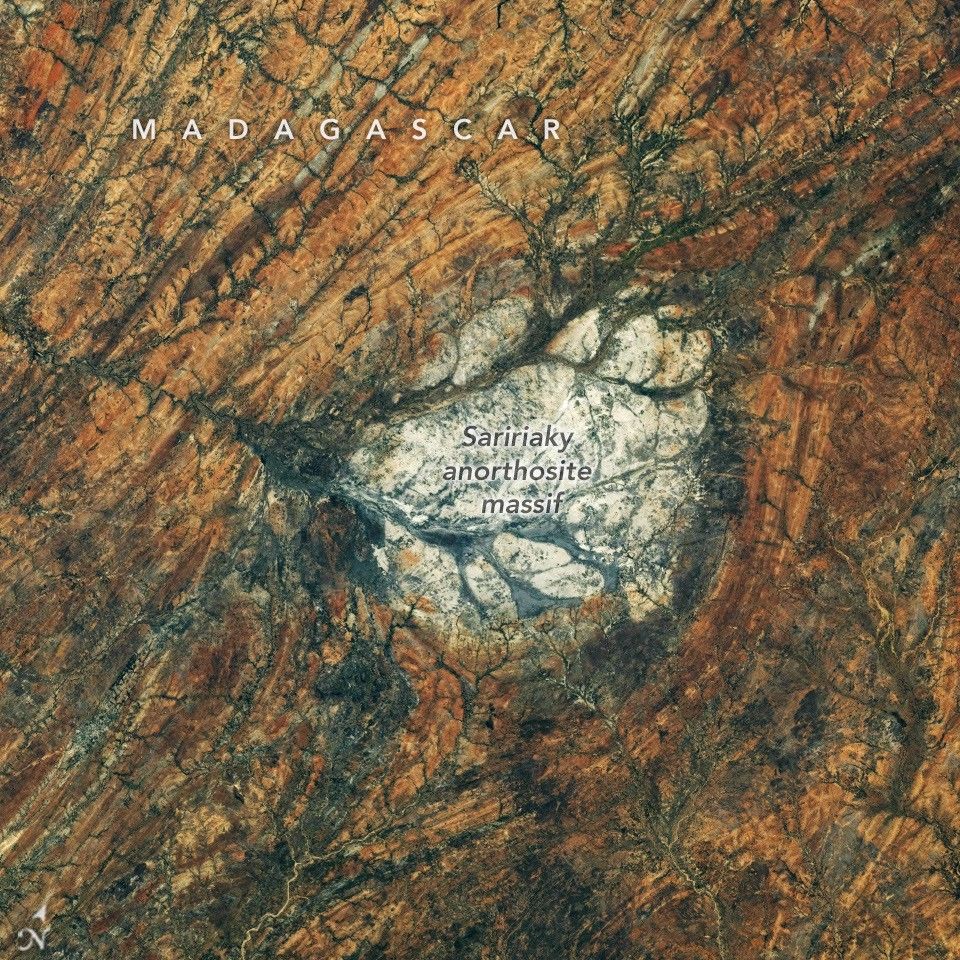
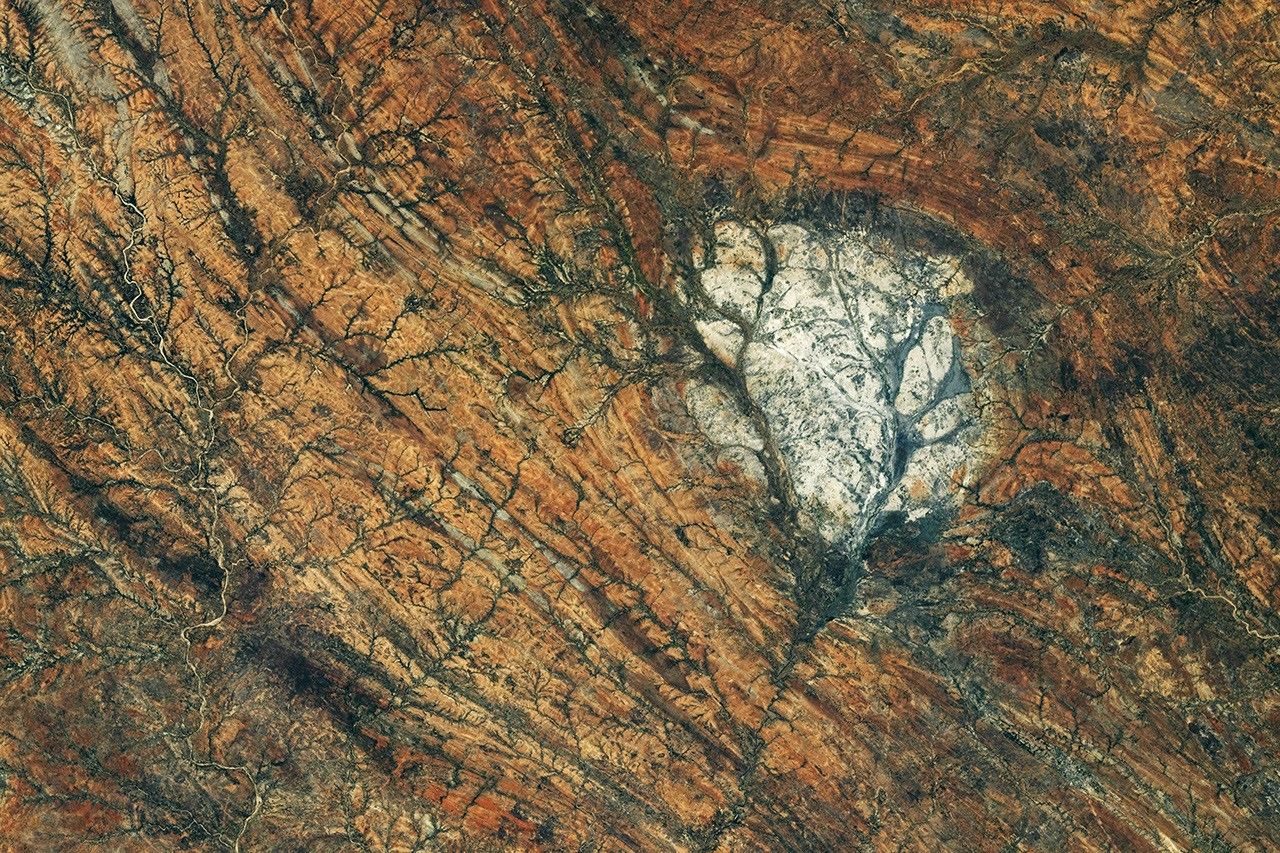
A round, white rock outcrop is surrounded by orange rocks with a north-south linear pattern. Branching riverbeds cut through the rock structures.

From an astronaut’s perspective looking back at Earth, a patch of bright rock in arid southern Madagascar may appear out of place. But it wouldn’t on the Moon. The igneous rock anorthosite, common on the Moon’s surface, is visible from Earth with the unaided eye as the light-colored, highly reflective areas known as the lunar highlands. Anorthosite also crops up across Earth’s surface, from eastern Canada and Scandinavia to southern India and Madagascar, where it forms a striking round feature.

An astronaut aboard the International Space Station captured this photo of the Saririaky anorthosite massif on August 28, 2026. Anorthosite is an intrusive igneous rock—formed from magma that cools beneath the surface—made up of large mineral crystals. Scientists think the massif seen here formed in the late Precambrian, at least 600 million years ago. Its present-day outcrop covers about 100 square kilometers (40 square miles).

The rocks surrounding the anorthosite reveal a dynamic chapter in the area’s geologic past. Researchers have determined that the Saririaky massif lies within a ductile shear zone, where high pressures and temperatures metamorphosed and reshaped the rock, imparting north-south-trending linear patterns.

Geologists think this deformation occurred when pieces of what are now Africa, India, Madagascar, Australia, and Antarctica were colliding to form the supercontinent Gondwana. Some scientists have posited that another anorthosite massif in the shear zone, located about 60 kilometers (40 miles) to the north, was pulled apart from the Saririaky massif in the process, creating a large-scale boudinage structure.

Anorthosites on Earth have proven useful for scientists studying the Moon’s past. Lunar anorthosites are more than 4 billion years old, having crystallized from the Moon’s magma ocean to form its outer crust. Researchers have analyzed samples brought back to Earth by Apollo astronauts, but because that material is limited, they also look to analogous terrestrial rocks. The anorthosites in the Beartooth Mountains of Montana match the composition of the lunar version particularly well. 

Astronaut photograph ISS075-E-85249 was acquired on August 28, 2026, with a Nikon Z9 digital camera using a focal length of 400 millimeters. It is provided by the ISS Crew Earth Observations Facility and the Earth Science and Remote Sensing Unit at NASA Johnson Space Center. The image was taken by a member of the Expedition 75 crew. The image has been cropped and enhanced to improve contrast, and lens artifacts have been removed. The International Space Station Program supports the laboratory as part of the ISS National Lab to help astronauts take pictures of Earth that will be of the greatest value to scientists and the public, and to make those images freely available on the internet. Additional images taken by astronauts and cosmonauts can be viewed at the NASA/JSC Gateway to Astronaut Photography of Earth. Story by Lindsey Doermann.

Downloads

A round, white rock outcrop is surrounded by orange rocks with a north-south linear pattern. Branching riverbeds cut through the rock structures.

August 28, 2026

JPEG (8.86 MB)

References & Resources

You may also be interested in:

Stay up-to-date with the latest content from NASA as we explore the universe and discover more about our home planet.

A Moonlit Earth as Seen From Artemis II

4 min read

An astronaut’s photo, taken en route to the Moon, reveals our planet and its place in space in a novel…

Article

An Epic View of the Seasons

6 min read

The tilt in Earth’s axis of rotation makes the apparent position of continents shift with the seasons in imagery from…

Article

The World Cup From 250 Miles Up

4 min read

Over the years, astronauts aboard the International Space Station have photographed several of the cities hosting the 2026 FIFA World…

Article


from NASA https://ift.tt/DxnpHT7

NASA Sets Coverage for SpaceX 35th Station Resupply Launch, Arrival

A SpaceX Dragon cargo spacecraft departs from the International Space Station on June 16 after undocking from the Harmony module’s forward p...