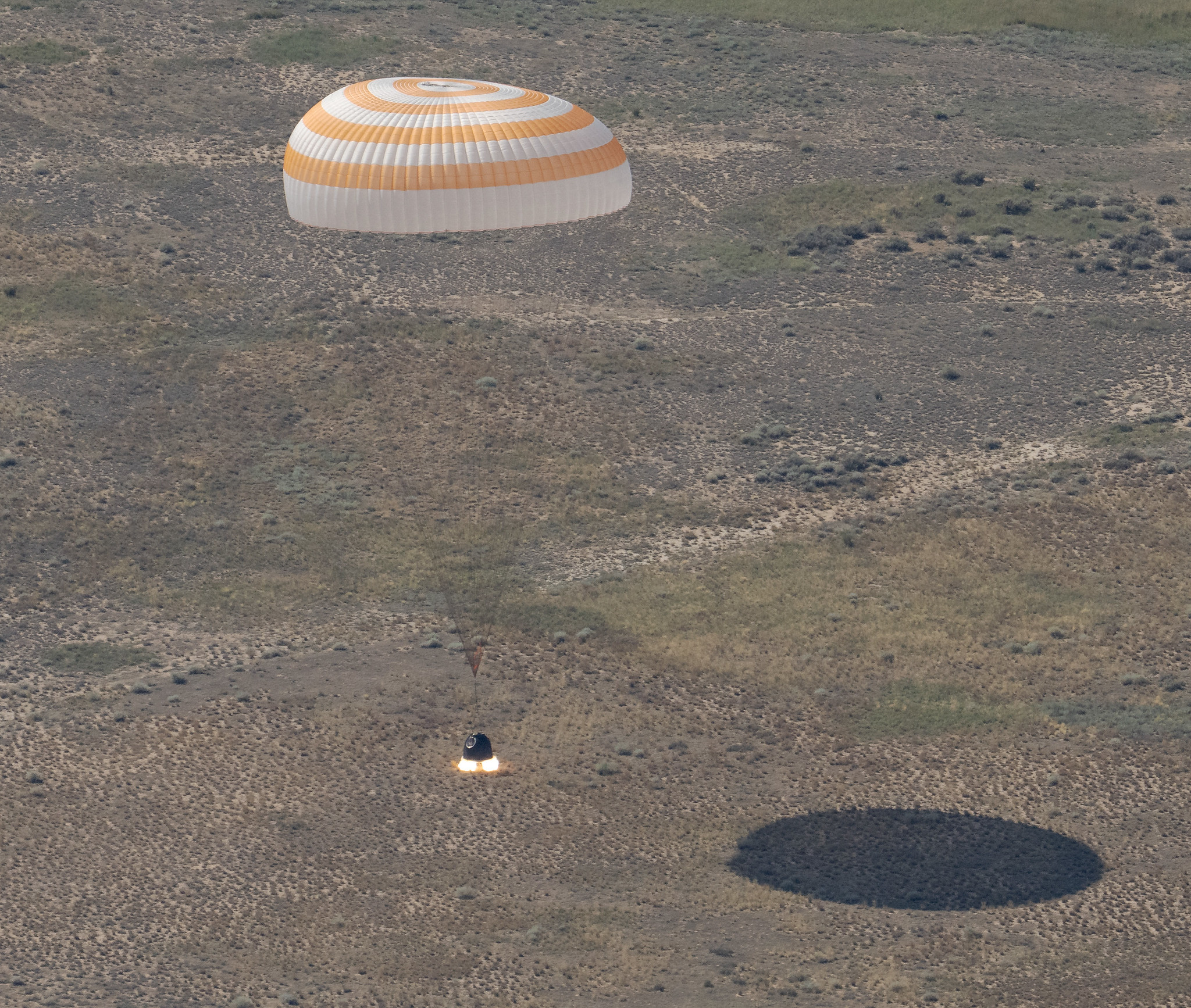
The Soyuz MS-28 spacecraft is seen as it lands in a remote area near the town of Zhezkazgan, Kazakhstan with Expedition 74 NASA astronaut Chris Williams, and Roscosmos cosmonauts Sergey Kud-Sverchkov, and Sergei Mikaev aboard, Sunday, July 26, 2026.
NASA/Bill Ingalls
Concluding an eight-month science mission aboard the International Space Station, NASA astronaut Chris Williams returned to Earth on Sunday alongside Roscosmos cosmonauts Sergey Kud-Sverchkov and Sergei Mikaev.
The crew made its safe, parachute-assisted landing at 5:27 a.m. CDT (3:27 p.m., Kazakhstan time), southeast of Dzhezkazgan, after departing the space station at 2:03 a.m., aboard the Soyuz MS-28 spacecraft.
The crew was in space for 241 days, orbiting the Earth 3,856 times and traveling more than 102 million miles. They launched to the International Space Station on Nov. 27, 2025. The mission was the first for Williams and Mikaev and the second for Kud-Sverchkov.
While aboard the orbiting laboratory, Williams supported a wide range of scientific investigations and technology demonstrations. He helped advance research for new cancer treatments and improved in-space manufacturing of materials used in high-performance computers and electronics. Williams also completed two spacewalks to prep for space station power system upgrades and to replace a faulty joint on the Canadarm2 robotic arm. The crew’s work aboard the space station helps improve life on Earth and prepare for future human missions to the Moon and Mars.
Following post-landing medical checks, the crew members will fly by helicopter to Karaganda, Kazakhstan, where recovery teams are based. Williams then will board a NASA aircraft bound for the agency’s Johnson Space Center in Houston.
For more than 25 years, people have lived and worked continuously aboard the International Space Station, advancing scientific knowledge and making research breakthroughs not possible on Earth. The space station helps NASA understand and overcome the challenges of human spaceflight, expand commercial opportunities in low Earth orbit, and build on the foundation for long-duration missions to the Moon, as part of the Artemis program, and to Mars.
To learn more about International Space Station research, operations, and its crews, visit:
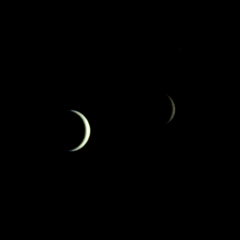
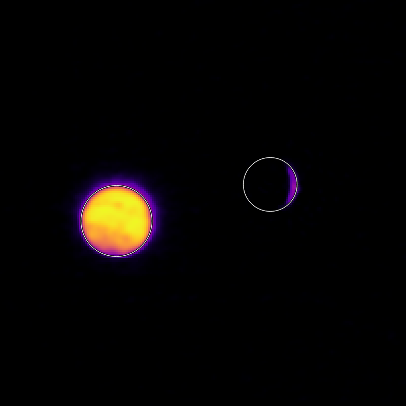
On July 3, one of NASA’s two Mars-destined ESCAPADE (Escape and Plasma Acceleration and Dynamics Explorers) spacecraft captured photos of Earth and the Moon in visible and thermal infrared light. At the time, the spacecraft was 363,250 miles (584,600 kilometers) from Earth and 115,600 miles (186,100 kilometers) from the Moon, making the Moon appear relatively large.
Taken with the Sun only partly illuminating Earth and the Moon, the visible light image shows the two bodies as crescents, with only around 8% of each face sunlit. Yet in the thermal infrared image, the shadowed hemisphere of Earth is illuminated by its own heat from both the atmosphere and surface, glowing at minus 10 to minus 44 degrees Fahrenheit (250 to 280 kelvins). Without the insulating blankets of oceans and atmospheres, the Moon’s far side remains at a much cooler minus 280 degrees Fahrenheit (100 kelvins).
visible light
thermal infrared light
Caption: In these images from NASA’s ESCAPADE mission, Earth (left) and Moon (right) can be seen. The image to the left of the slider shows visible light reflected by the Sun while the infrared image to the right shows the bodies’ emitted energy. White rings have been added in the thermal image to show the actual size of Earth and the Moon. Credit: NASA/UCB-SSL/NAU-Radiant/Lucint
NASA/UCB-SSL/NAU-Radiant/Lucint
In these images from NASA’s ESCAPADE mission, Earth (left) and Moon (right) can be seen. The image to the left of the slider shows visible light reflected by the Sun while the infrared image to the right shows the bodies’ emitted energy. White rings have been added in the thermal image to show the actual size of Earth and the Moon.
NASA/UCB-SSL/NAU-Radiant/Lucint
visible light
thermal infrared light
ESCAPADE Photos of Earth and Moon
July 3, 2026
In these images from NASA’s ESCAPADE mission, Earth (left) and Moon (right) can be seen. The image to the left of the slider shows visible light reflected by the Sun while the infrared image to the right shows the bodies’ emitted energy. White rings have been added in the thermal image to show the actual size of Earth and the Moon. Credit: NASA/UCB-SSL/NAU-Radiant/Lucint
The ESCAPADE mission used its Visible and Infrared Observation System cameras, provided by Northern Arizona University in Flagstaff, to capture the images, which are more than just road trip photo album snaps.
“We are thrilled that ESCAPADE was able to accommodate these excellent space-qualified cameras which will search for visible Martian aurora and investigate thermal properties of the Martian surface and atmosphere,” said Rob Lillis, the mission’s principal investigator at the University of California, Berkeley. “Since Earth and the Moon are well-known targets, imaging them provides an important calibration check for ESCAPADE’s cameras.”
The ESCAPADE spacecraft, which were built by Rocket Lab, are currently in a “loiter” orbit around Lagrange point 2, a location in space about a million miles from Earth. In November 2026, the spacecraft will fly by Earth to use the planet’s gravity to slingshot their way to Mars. When the spacecraft arrive in September 2027, they will study how a million-mile-per-hour stream of material flowing from the Sun, known as solar wind, interacts with the Martian environment and how that drives atmospheric loss at the Red Planet.
The ESCAPADE mission is funded by NASA’s Heliophysics Division and is part of the NASA Small Innovative Missions for Planetary Exploration program. The UC Berkeley’s Space Sciences Laboratory leads the mission with key partners Rocket Lab; NASA’s Goddard Space Flight Center in Greenbelt, Maryland; Embry-Riddle Aeronautical University; Advanced Space; and Blue Origin.
By Mara Johnson-Groh NASA’s Goddard Space Flight Center, Greenbelt, Md.
This NASA/ESA Hubble Space Telescope image features the spiral galaxy NGC 4654, located 72 million light-years away in the constellation Virgo (the Maiden).
NASA, ESA/Hubble, D. Thilker, J. Lee, and the PHANGS-HST Team
The subject of this NASA/ESA Hubble Space Telescope image is a spiral galaxy struggling against titanic forces that appear on galactic scales in space. This is NGC 4654, an intermediate spiral galaxy in the constellation Virgo (the Maiden). It is classified as an “intermediate” because its overall shape lies between spiral galaxies that have a bar across their centers and those that don’t. NGC 4654 has a weak bar structure at its center and is located 72 million light-years from Earth in the Virgo Cluster, a particularly massive and populous galaxy cluster.
NGC 4654 is particularly asymmetric, with a rounded and clearly-defined edge on one side and a long tail of gas stretching out from the opposite side — outside the field of view captured in this image. This gaseous tail is the result of ram pressure stripping, a force that galaxies can experience as they plow through space. NGC 4654 moves with such high velocity that it sweeps up and rams through the hot, rarefied gas filling the space between the Virgo Cluster’s galaxies. This intracluster medium in turn exerts a “ram pressure” on the galaxy, compressing the galaxy’s leading edge and dragging its gas behind the galaxy, creating the elongated tail.
It’s not just the galaxy’s gas that is unevenly distributed: its stars are too, and this is more unusual for a spiral galaxy. While the spiral arm on its leading edge is rich with stars and gas, the opposite arm noticeably lacks stars, influencing the galaxy’s lopsided spiral shape. Astronomers think that ram pressure alone is unlikely to cause this effect. Rather, NGC 4654 was also subjected to the gravitational force of fellow Virgo Cluster galaxy NGC 4639. While the two galaxies are far apart now, it’s thought that a fly-by interaction between them around 500 million years ago ripped away NGC 4654’s gas along one side, limiting star formation there and creating the asymmetry in its shape.
Many galaxies that undergo ram pressure stripping suffer reduced star formation rates as the cold gas that collapses to form their stars is pulled away and lost. NGC 4654, however, is still forming nearly two Suns’ worth of stars every year, a rate comparable to other galaxies of similar size. The active star formation is visible in the latest Hubble data included in this image. The data picks up on a wavelength of red light emitted by the clouds of energized gas where newborn stars lurk. The bright pink bubbles that appear across NGC 4654 — from its forward spiral arm, to around its weak bar, and out to the edge of its disk — are areas where these newborn stars shine.
The data used in this image came from two observing programs (#15654, #17502) that aim to link the gas in galaxies with star formation. By observing many prominent galaxies in the vicinity of our own, researchers hope to better understand how gas moves in galaxies, where and when it collapses to form stars and star clusters, and what effect those new stars have on the gas around them.
A dry, tan-colored valley containing a few circular irrigated fields runs roughly north-south through the image.
NASA Earth Observatory / Lauren Dauphin
Grid-like arrays of solar panels cover parts of a valley floor in a brown, dry-looking area of Utah.
NASA Earth Observatory / Lauren Dauphin
A dry, tan-colored valley containing a few circular irrigated fields runs roughly north-south through the image.
NASA Earth Observatory / Lauren Dauphin
Grid-like arrays of solar panels cover parts of a valley floor in a brown, dry-looking area of Utah.
NASA Earth Observatory / Lauren Dauphin
June 16, 2024
June 6, 2026
The nearly one million photovoltaic panels of a solar energy and battery storage facility in Utah appear in the right image, acquired with the OLI (Operational Land Imager) on Landsat 8 on June 6, 2026. The same sensor captured the left image on June 16, 2024. NASA Earth Observatory images by Lauren Dauphin.
Historically, central Utah’s Castle Valley has been a coal hub, with mining operations on the slopes of the Wasatch Plateau to the west active since the late 1800s. A different energy development arrived in the region in June 2026, when a large solar power and battery storage plant came online in the sunny valley about 130 miles (210 kilometers) southeast of Salt Lake City.
The recently constructed Green River Energy Center, seen in the Landsat 8 image above (right), features nearly one million solar panels and roughly 500 batteries on several square miles of previously undeveloped land. The facility has 400 megawatts of solar-generating capacity with another 400 megawatts of battery storage. That places it among the many utility-scale solar power and battery storage projects that the U.S. Energy Information Administration expects to be plugged into the country’s grid in 2026.
The Utah facility is slated to supply power to Salt Lake City and other areas across the state, according to news reports, and project staff estimate it could produce enough electricity for more than 100,000 homes. With its integrated battery storage, the plant has the potential to generate power at all hours, even when the Sun isn’t shining. And the Green River Energy Center can build on Castle Valley’s energy legacy by utilizing existing transmission lines originally built for coal-fired power plants in the area.
Though Utah adopted coal as its state rock and has long relied on it for energy, other sources, such as solar and geothermal, are becoming larger parts of the state’s energy mix. In 2025, coal fueled about half of the state’s electricity generation, down from about 75 percent in 2015. Meanwhile, solar grew to account for about 14 percent of generation in 2025, up from nearly zero a decade before. Satellite data can be useful to planners and policymakers involved in energy transitions for assessing the potential of renewable energy systems and tracking their adoption and performance.
NASA Earth Observatory images by Lauren Dauphin, using Landsat data from the U.S. Geological Survey. Story by Lindsey Doermann.
Curiosity Blog, Sols 4954–4960: Celebrating Our Rover Engineers Past and Present
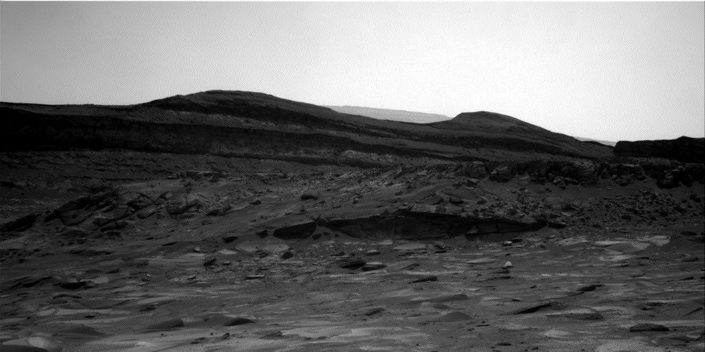
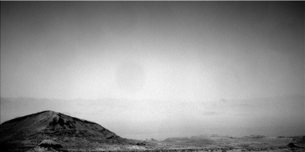
In this image acquired by NASA’s Mars rover Curiosity, the relatively light-toned bedrock in the foreground gives way to darker-toned rocks in the middle of the image, along what could be an erosional surface. Curiosity acquired the image using its Right Navigation Camera on July 15, 2026 — Sol 4955, or Martian day 4,955 of the Mars Science Laboratory mission — at 05:51:59 UTC.
NASA/JPL-Caltech
Written by Lucy Thompson, Senior Research Scientist, University of New Brunswick, Canada
Earth planning date: Friday, July 27, 2026
As an APXS uplink lead and strategic planner, I have the privilege of working with the rover engineers most days that I am on operations. The APXS instrument measures the chemistry of rocks, unconsolidated materials and the atmosphere, and is situated on the end of Curiosity’s robotic arm. This means that any target of interest that we wish to analyze has to be safe to deploy the arm, APXS, and MAHLI (the closeup imager) to. We therefore rely on the rover engineers for their assessment and to sequence the arm moves to place us safely on the targets. Recently, our workspaces have been dusty with varied relief, but the rover engineers have successfully found areas that they have been able to brush and deploy APXS and MAHLI. This week was no exception, despite some of our workspaces appearing less than ideal upon initial observation. The team managed to find rock targets of interest (x5), which the rover engineers were able to safely place the arm on and brush so that we could analyze them with APXS and MAHLI. This ensures that we acquire high-quality compositional data and images as we continue our ascent of Mount Sharp, through rock layers of varying tone and texture, tracking potential changes in chemistry, and the depositional and alteration environment.
The rover engineers are also responsible for safely driving Curiosity to the areas of interest identified by the science team. They must assess the terrain for potential hazards such as large resistant blocks that could damage the rover wheels, sand/soil patches where we could get stuck, and high slopes that the rover could slip on. Despite unexpected damage to the wheels early in the mission and getting a little bogged down in some soil/sand just as we started to climb Mount Sharp, the engineers have successfully navigated us safely along more than 23 miles (37 kilometers) of drive distance and more than 4,400 feet (about 1.35 kilometers) of elevation gain. We recently requested to drive to specific locations in order to image what the team thinks could be an erosional surface within the Mg-sulfate/carbonate-bearing unit (see the image accompanying this post). Of course, the engineers were able to accommodate our desires, with the first stop crossed off in Monday’s plan, and the drive that is being planned this weekend taking us toward the next stop.
The rover engineers also ensure that our drilling activities execute safely and successfully, and are responsible for sequencing the arm motion required to deliver the drilled samples to our internal CheMin and SAM instruments. This required completely reconfiguring how we drill after a motor failed back in 2016, with extensive behind-the-scenes work at JPL for nearly a year and a half before we resumed. Curiosity has since drilled more than 20 rock targets.
So, thanks to the rover engineers and all the engineers and scientists on Curiosity’s team, we have had another full week of activities at Gale crater. We continue to track the chemistry, textures, tone and sedimentary structures of the sulfate/carbonate unit as we climb Mount Sharp and get ever closer to the Yardang unit with APXS, ChemCam, MAHLI and Mastcam. Curiosity continues to also monitor the local environment within Gale and the atmosphere in general.