Discover the cosmos! Each day a different image or photograph of our fascinating universe is featured, along with a brief explanation written by a professional astronomer.
New Sharpest Image of the Sun Uncovers Instability
Explanation: What does the new sharpest image of our Sun show? Instability. To be clear, a certain kind of interactive process called the Kelvin-Helmholtz instability (KHI). This instability can create waves and swirls when two streams flow past each other — in this case variable streams of solar magnetic plasma. Long hypothesized to occur on the Sun’s surface, KHI streaks and swirls were confirmed in just-released dramatic high-resolution images taken recently by the Inouye SolarTelescope in Hawaii, USA. The featured false-yellow image, actually taken in deep blue, is the highest resolution image yet of the Sun in visible light. It spans about the radius of the Earth, but its finest details are city sized. Visible are several smooth tops of changing solar granules, while the edges of the flower-like structures have been found to harbor multiple KHI swirls. Future research may investigate how the KHI helps move energy, magnetic fields, and may even heat the surrounding solar corona.
A first of its kind measurement of a magnetar may have captured empty space behaving in a way physicists have predicted for 90 years, but never directly observed. The results published Wednesday in Nature.
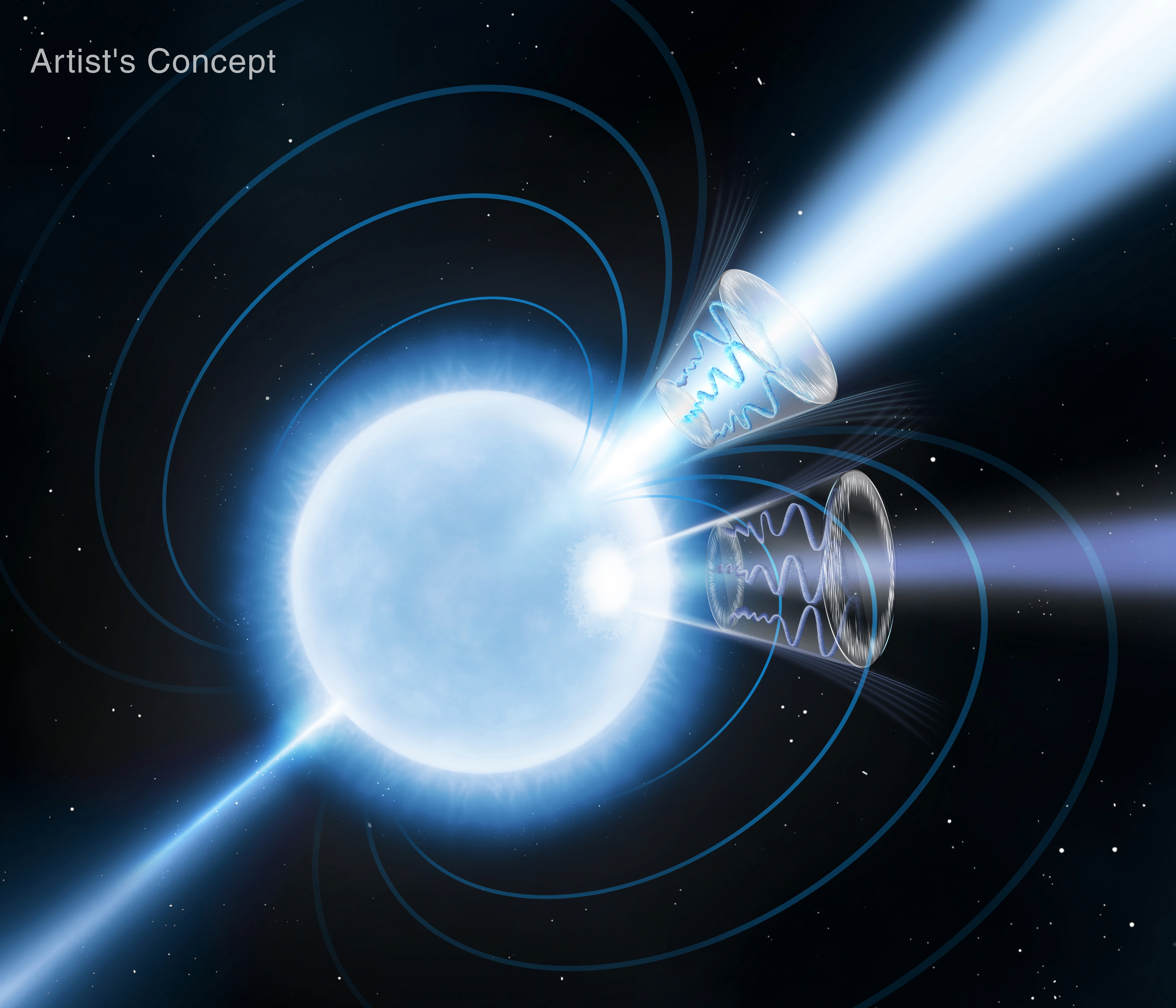
This artist’s concept depicts magnetar 1E 1547.0-5408, a rapidly rotating neutron star with magnetic fields over a trillion times stronger than Earth’s. Blue curves emanating from the star’s two magnetic poles represent the magnetic field lines. The magnetar is a significant emitter of radio and X-ray radiation, with their peaks offset during its 2.1-second rotation period. This indicates the primary X-ray emitter is a secondary “hot spot” offset from the magnetic axis. These emitters are depicted as conical sections: the lighter blue radio emission peaks at the magnetic field’s symmetry axis, while the darker blue X-ray emission peaks below. The upper and lower emission cones show X-ray polarization degrees of 40% and 80%, respectively. These high values, along with smooth, coherent variations in polarization across the rotation period, provide the most definitive signal to date of vacuum birefringence a long-sought prediction of quantum electrodynamics.
NASA/Pablo Garcia
Fast facts
Magnetars are a special class of neutron stars with ultra-strong magnetic fields, the strongest of any object in the observable universe, around a trillion times stronger than the strongest permanent magnets ever built on Earth. These super magnetic neutron stars offer glimpses into the physics of intense environments that cannot be found anywhere else.
Neutron stars are the leftover cores of massive stars, formed at the end of their life cycles, that possess more mass than the Sun, condensed down to the size of a city, making them natural laboratories for studying extreme physics.
Scientists using NASA’s IXPE (Imaging X-ray Polarimetry Explorer) conducted more than 140 hours of observations of the magnetar 1E 1547-5408, between March and April 2025, alongside NASA’s NICER (Neutron Star Interior Composition Explorer) and Murriyang, CSIRO’s Parkes radio telescope, owned and operated by Australia’s national science agency. This was the first-ever coordinated radio and X-ray polarization measurement of a magnetar.
1E 1547-5408, spinning in a full rotation every 2 seconds, is a unique magnetar that consistently emits bright radio energy and X-ray light, for reasons scientists are still trying to understand.
Observations showed the polarization, or the orientation and level of alignment of the incoming photons, is nearly three times greater than seen in similar sources. This high level of polarization was surprising, since the geometry of the magnetar’s magnetic fields suggest that the measurements we see should be close to zero at certain points in the star. Standard surface emission models do not explain this large value either, indicating that another effect must be boosting the polarization.
Enter vacuum birefringence, a 90-year-old theory in the realm of quantum electrodynamics. First proposed in 1936, the theory suggests that the vacuum of space can be altered by extreme magnetic fields, far higher than those humans can create on Earth. Under such conditions, the vacuum acts like a lens or a prism, filtering light based on the direction it is traveling, therefore enhancing its total polarization. The IXPE mission’s ability to measure X-ray polarization was essential to test this theory.
Simulations performed by the research team support the possibility of vacuum birefringence causing the distinct signal. Hoa Dinh Thi, a postdoctoral associate at Rice University in Houston and co-lead author of the publication highlighting the results, said, “Our model suggests that reproducing the observed X-ray polarization signatures, while also satisfying the constraints set by radio observations, requires the presence of vacuum birefringence in the neutron star’s environment. This finding exemplifies how neutron stars enable us to test fundamental physics in environments not replicable in labs on Earth.”
The large polarization measurements from the magnetar give strong support to the theoretical prediction, and could be the first time this effect has been directly observed anywhere.
“This result truly highlights the interdisciplinary power of the field of astrophysics,” said Rachael Stewart, a Ph.D. candidate at George Washington University and lead author of the paper published in Nature. “The information we obtained from looking at this distant star core also gives us clues about the nature of the fabric of reality as we know it, and I find that to be incredible.”
Further IXPE observations of this source and other magnetars will confirm this signal and potentially reveal other exotic effects of quantum electrodynamics.
More about IXPE
The IXPE mission, which continues to provide unprecedented data enabling groundbreaking discoveries about celestial objects across the universe, is a joint NASA and Italian Space Agency mission with partners and science collaborators in 12 countries. It is led by NASA’s Marshall Space Flight Center in Huntsville, Alabama. Headquartered in Falls Church, Virginia, BAE Systems, Inc., manages spacecraft operations together with the University of Colorado’s Laboratory for Atmospheric and Space Physics in Boulder. Learn more about IXPE’s ongoing mission here:
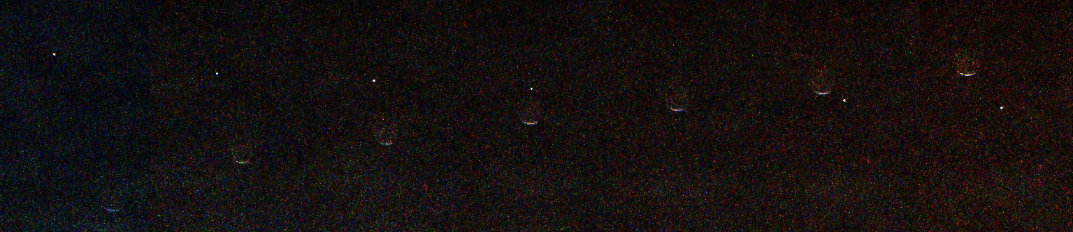
This composite of seven images from the Mastcam-Z instrument aboard NASA’s Perseverance Mars rover shows Earth, visible as a small bright dot moving from upper left to lower right, passing behind the Martian moon Phobos on July 2, 2026, 1,907th Martian day, or sol, of the mission.
The black background is the result of image processing that removed extraneous light in the background to enhance detail.
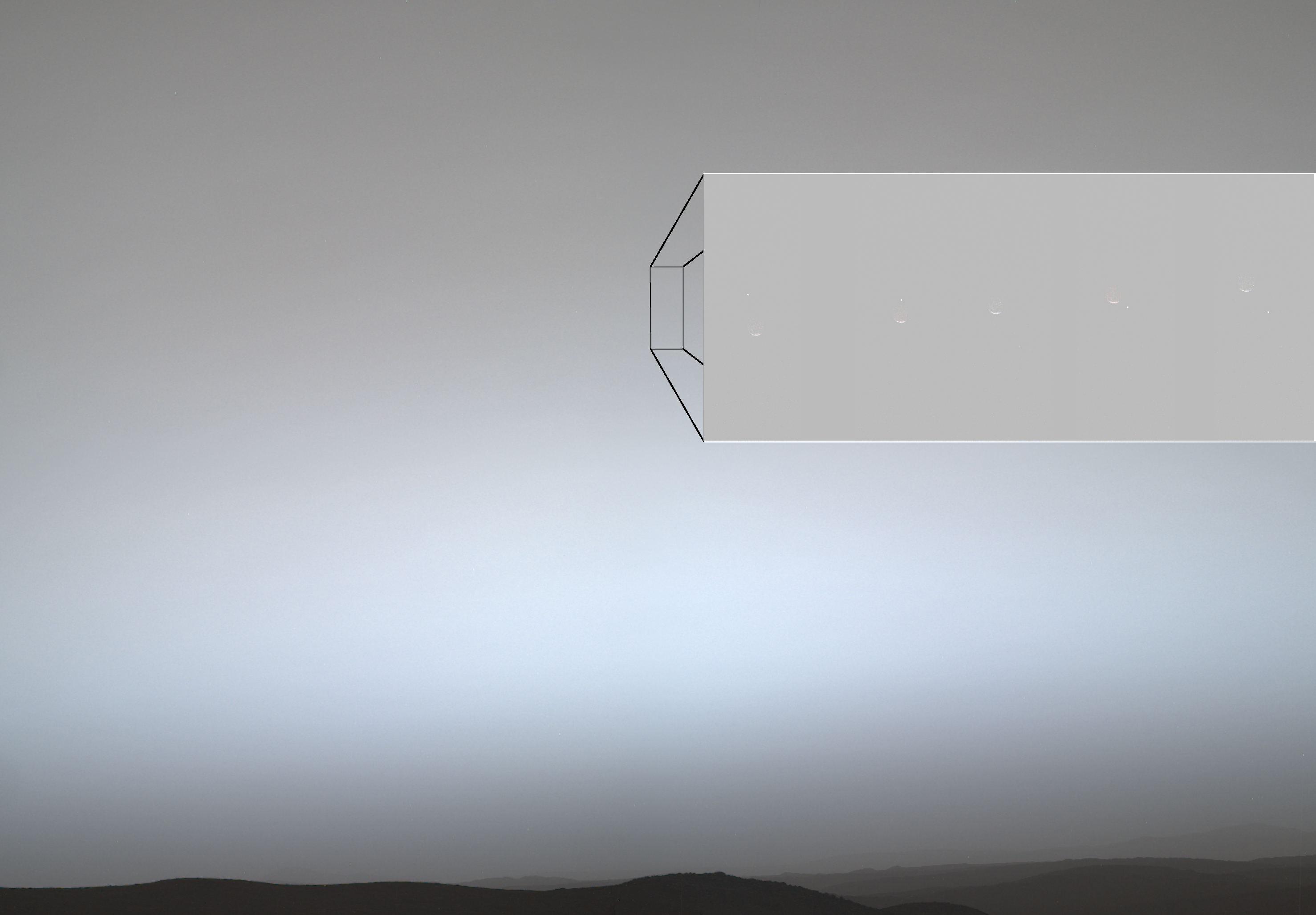
Figure A
Figure A is an annotated composite of nine images taken by the Mastcam-Z instrument aboard Perseverance on July 2, 2026. The inset on the upper right, comprised of five images, shows Earth — the small bright dot moving from upper left to lower right — passing behind the Martian moon Phobos.
The rectangle outlined at the left in the annotation indicates the patch of sky that was imaged several times to capture Earth passing behind Phobos. In the larger rectangular inset, the images captured from that patch of sky are displayed in time order from left to right, with Phobos moving up and Earth moving down.
The gray of the Martian sky is the approximate true color of the twilight (about 40 minutes after sunset) on that sol. It is blue-gray lower, where it is brighter, and reddish gray above.
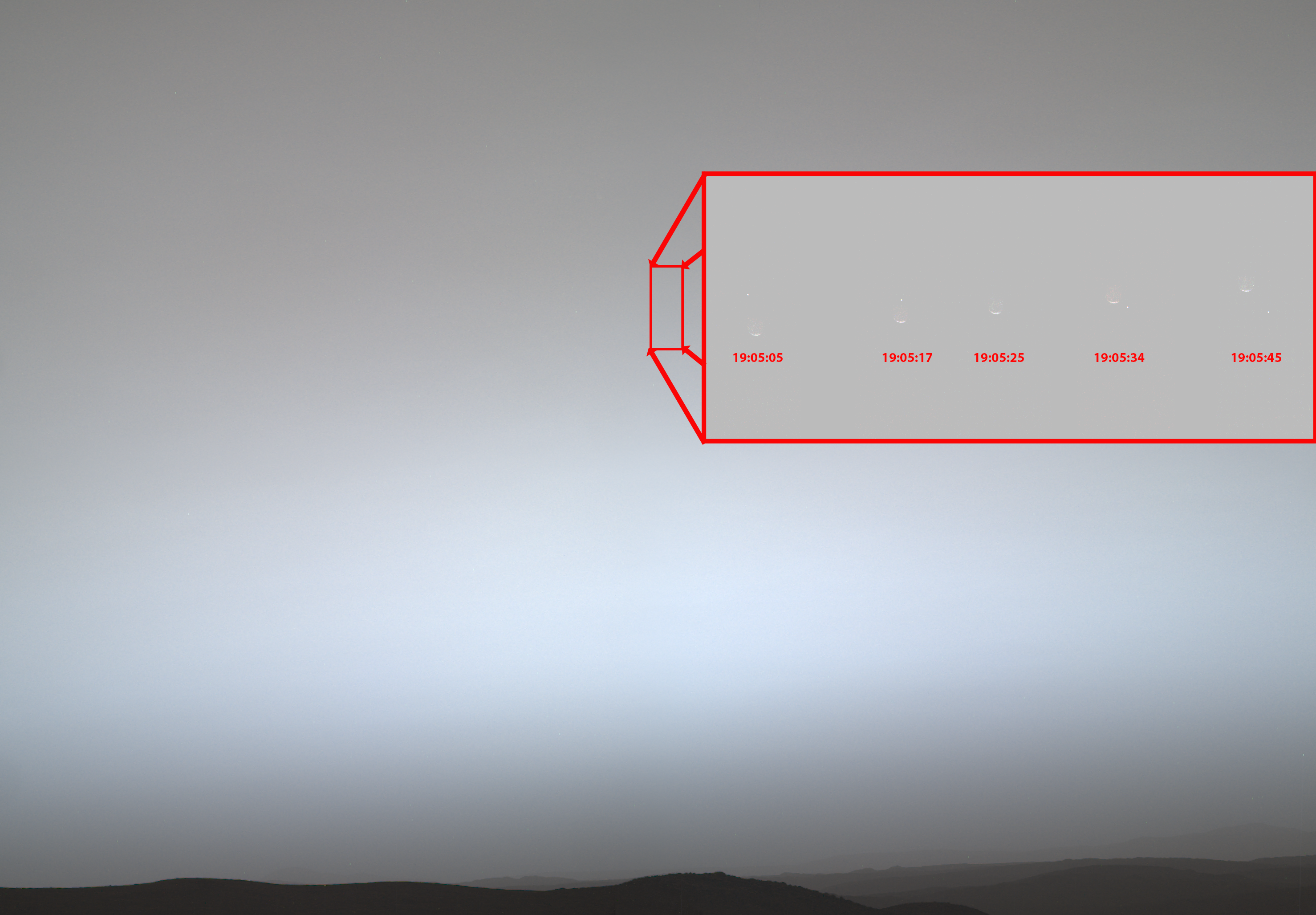
Figure B
Figure B includes annotations showing the local solar time on Mars during which the five individual images that captured the occultation were taken.
NASA’s Jet Propulsion Laboratory in Southern California, which is managed by Caltech, built and manages operations of the Perseverance rover on behalf of the agency’s Science Mission Directorate in Washington, as part of NASA’s Mars Exploration Program portfolio. Arizona State University leads the operations of the rover’s Mastcam-Z instrument, working in collaboration with Malin Space Science Systems in San Diego, on the design, fabrication, testing, and operation of the cameras.
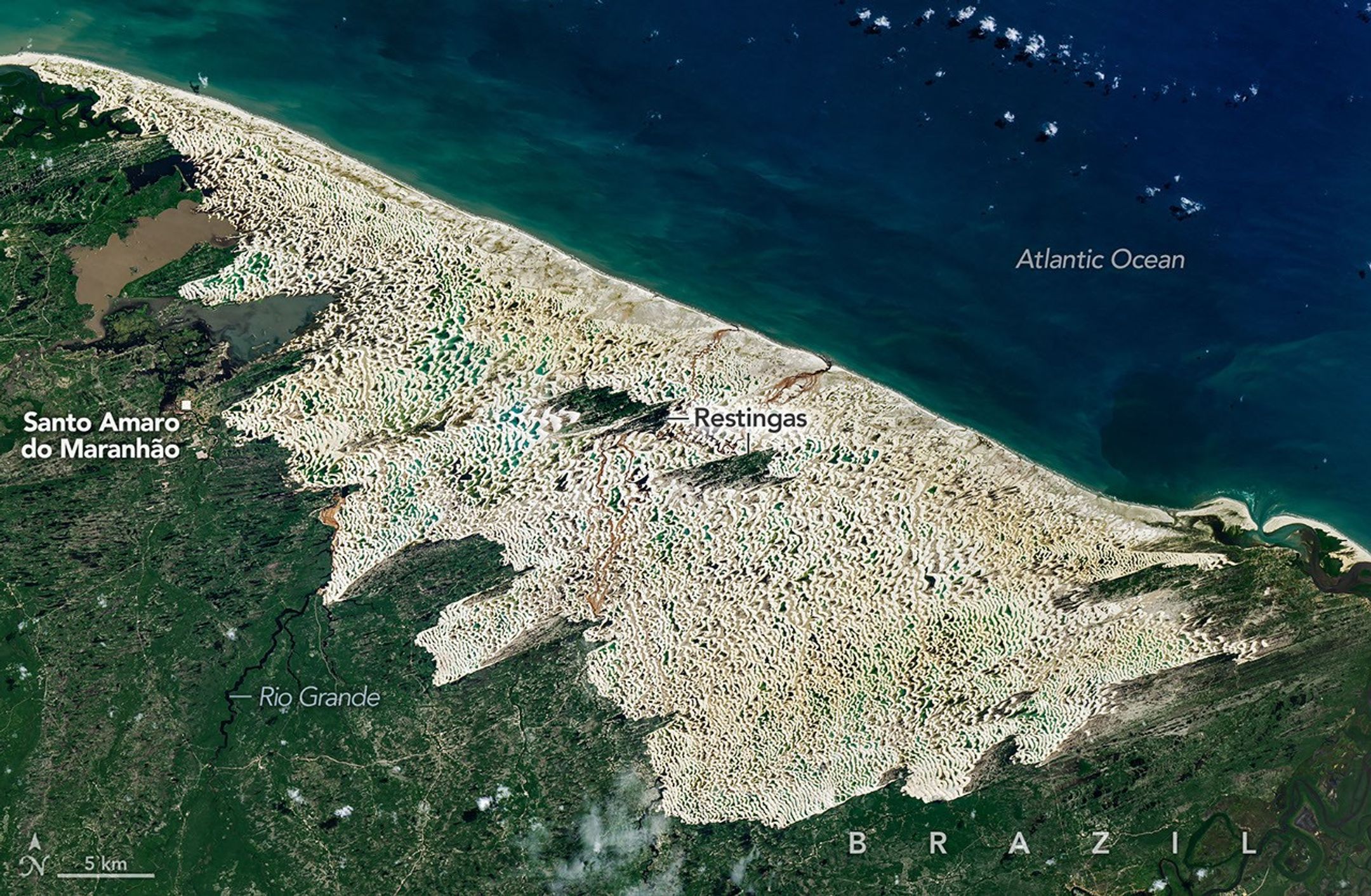
A mosaic of hundreds of freshwater lagoons partially filled the troughs around many of the park’s dunes when the OLI (Operational Land Imager) on Landsat 9 captured this image on June 8, 2026.
NASA Earth Observatory/Michala Garrison
The coastal dune system in Lençóis Maranhenses National Park in northeastern Brazil is among the most surreal landscapes on Earth. At first glance, the park looks like a desert, but it is far from it. This place receives about 125 centimeters (50 inches) of rain per year—slightly more than Seattle and double what falls in London.
The result is a paradox: rows of sparkling white quartz dunes, some rising 30 meters (100 feet), soar over a mosaic of blue and green freshwater lagoons. The park’s name stems from the Portuguese word lençóis, meaning “bedsheets,” a reference that makes the most sense when the park is viewed from afar. From that perspective, the sweeping curves of the largest coastal dune field in South America resemble a rumpled, white bedsheet.
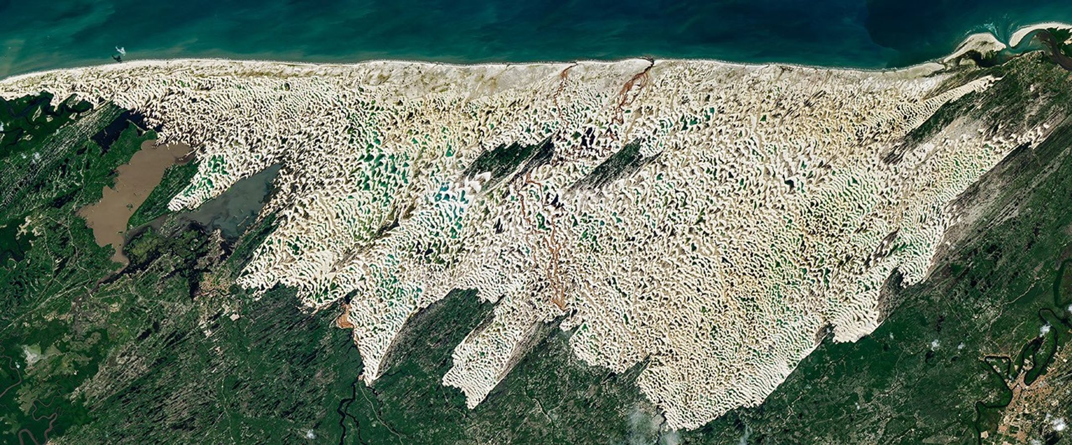
These Landsat 9 images were captured in June 2026, around the time when lagoon water levels typically peak. The partially impermeable layer of bedrock and clay beneath the sand prevents the lagoons from draining during the wet season. However, as rains subside between August and November, the water table falls, and by December, most of the lagoons dry up.
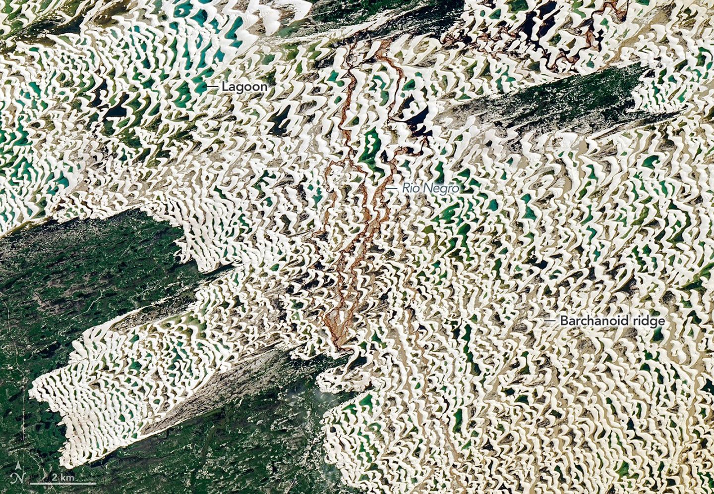
Winds blowing from the northeast created the lines of dunes visible in this detailed view of a portion of the Landsat 9 image shown above.
NASA Earth Observatory/Michala Garrison
The dune field, a tan area within an expanse of green, is the centerpiece of the park. It spans about 900 square kilometers (350 square miles), roughly the size of New York City. From above, shallower lagoons appear light blue, often taking on turquoise or aquamarine hues as sunlight reflects off the sand below. Deeper lagoons are darker, a result of the deeper water absorbing more red, yellow, and green wavelengths, leaving mostly blue light to scatter back. Suspended sediment, microscopic algae, and dissolved organic matter also contribute to the array of colors, giving some lagoons greener and browner tones.
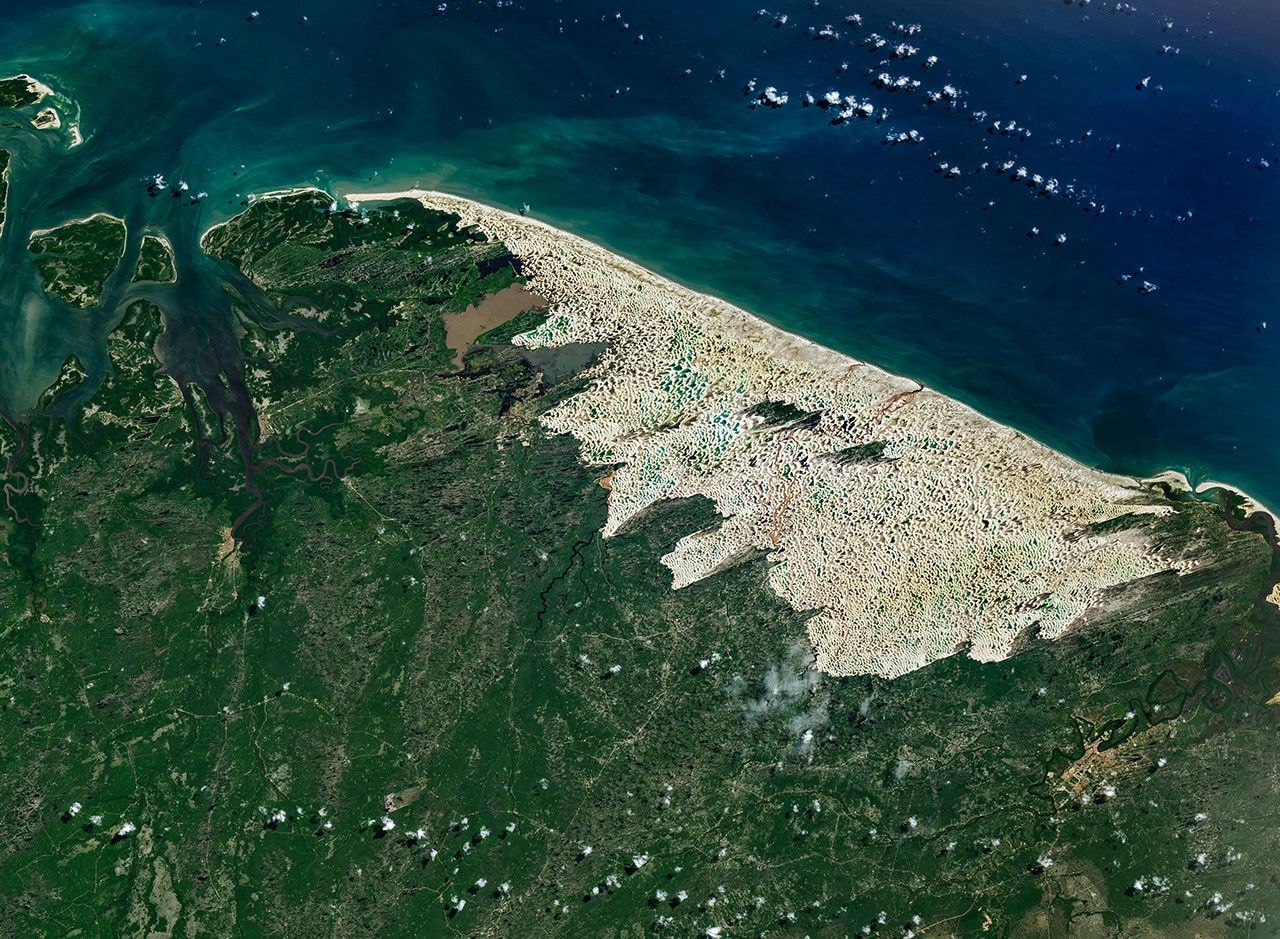
Green vegetation surrounds the dune field, which sits at the intersection of three Brazilian biomes: the Amazon rainforest to the west, the tropical wooded savannas of the Cerrado to the south, and the dry shrublands and thorn forests of the Caatinga to the east. Closest to the dunes are mangroves and restinga forests, ecosystems well adapted to sandy, coastal soils.
The dune field exists because of the rare convergence of geologic and climatic conditions. Rivers, including the Mearim and Parnaíba, deliver the key ingredient—quartz sand—to this unusually flat portion of the Maranhão coastline in massive quantities. It has accumulated here over the past few hundred thousand years driven in part by fluctuating sea levels and shorelinetransgression and regression. Persistent easterly trade winds have also played a critical role. During the dry season, winds often reach at least 50 kilometers per hour, fast enough to build the dunes and push them westward at a pace of roughly 4 to 25 meters per year. That is fast for sand dunes, though not the fastest in the world. Satellites have tracked small barchan dunes in Namibia’s Sperrgebiet region moving at rates exceeding 80 meters per year.
NASA Earth Observatory/Michala Garrison
Landsat images, meanwhile, show the dune field at Lençóis Maranhenses has extended westward by about 0.5 kilometers between 1986 and 2026 in some areas due to the conveyor belt of dunes running inland from the coastline. The nearly constant movement of sand prevents vegetation from becoming established across much of the dune field.
UNESCO declared the park a World Heritage site in 2024, citing its remarkable geology and rich biodiversity. The park is home to more than 850 documented species, including fish, birds, reptiles, mammals, and phytoplankton. Among them are four endangered species, including the neotropical otter, West Indian manatee, scarlet ibis, and oncilla (a type of wild cat). Among the lagoons’ most remarkable inhabitants are the trahira (Hoplias malabaricus), a predatory fish species with large canine-like teeth. During the dry season, it burrows far enough under the sand to find damp mud, where it enters a dormant state, emerging after the rains to hunt insects and other fish.
NASA Earth Observatory images by Michala Garrison, using Landsat data from the U.S. Geological Survey.Story by Adam Voiland.
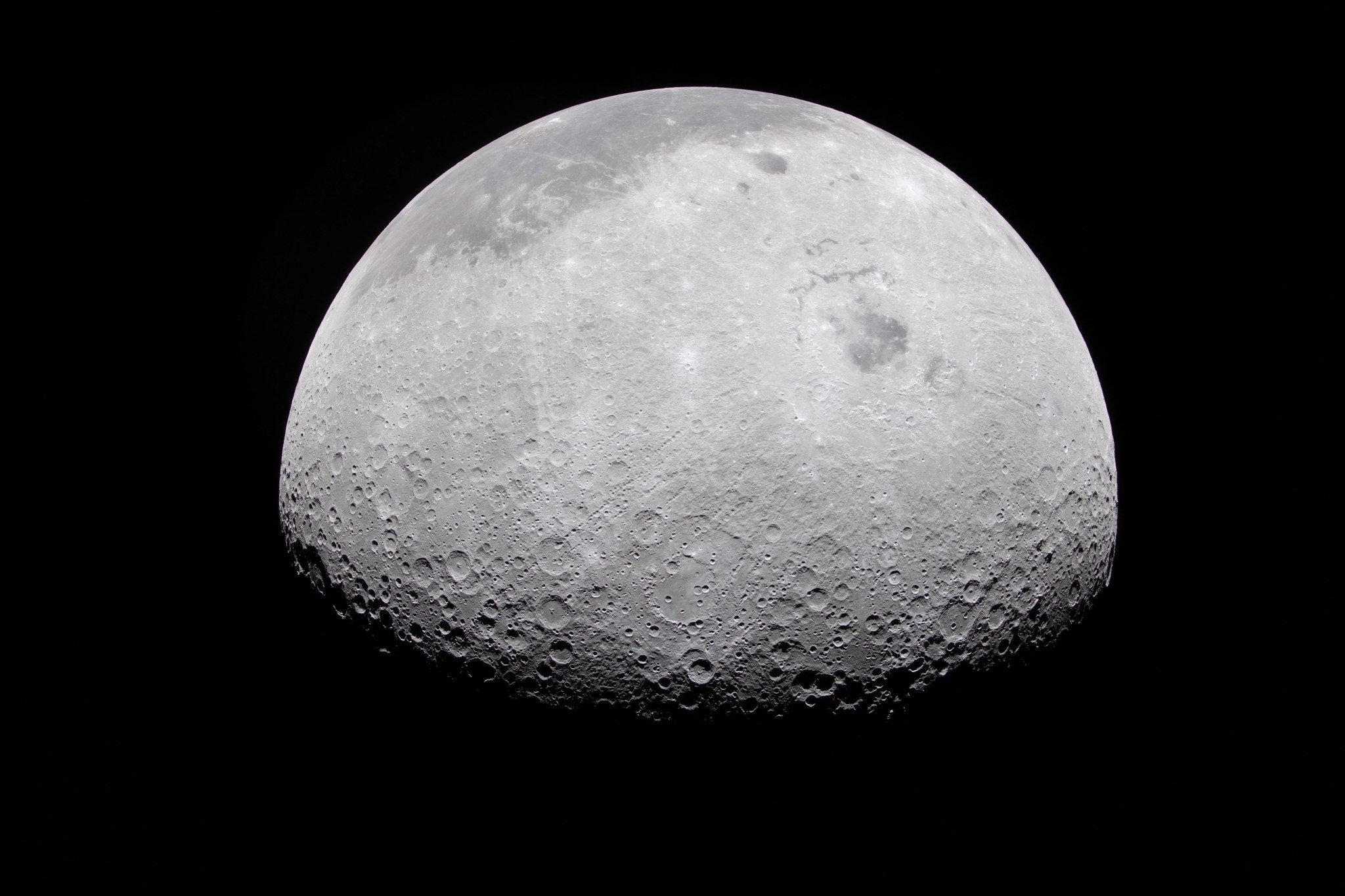
The Moon’s rocky, uneven, and otherworldly surface features are highlighted by the terminator – the difference between light and darkness.
NASA
Using ground-based telescopes and space-based assets, NASA and SpaceX are tracking a used Falcon 9 upper stage from a commercial mission expected to impact the Moon on Wednesday, Aug. 5, near the Einstein and Bell craters. The impact poses no danger to Earth and NASA scientists are planning to collect lunar data from the event and refine techniques for tracking objects in space.
On Jan. 15, 2025, SpaceX launched the Falcon 9 rocket and successfully deployed Firefly Aerospace’s Blue Ghost 1 lunar lander to the Moon under NASA’s CLPS (Commercial Lunar Payload Services) initiative. Solar activity and gravitational forces caused the stage’s unplanned return to the Moon. NASA and SpaceX remain in communication about the upper stage and its flight path.
Independent astronomers first identified the trajectory using publicly available data. NASA’s Center for Near Earth Object Studies at the agency’s Jet Propulsion Laboratory in Southern California, which tracks natural objects that could pose hazards to Earth, later confirmed the stage has a 100% chance of impacting the Moon. NASA will continue tracking it as part of training operations.
Because the Moon has no atmosphere to slow incoming objects, it is struck by meteoroids daily. Human‑made object impacts are far less common but do occur. The rocket stage is expected to create a crater about 60 feet wide and 12 feet deep and throw dust and rock outward as ejecta. For comparison, a meteoroid with the same energy as the upper stage hits the Moon about every six days, so the lunar surface is constantly absorbing impacts with the same force. Despite the disturbance, observing impacts gives scientists valuable insight by revealing how ejecta plumes behave, helping to understand the Moon’s geology and refine models that guide future exploration and science missions.
The impact will not be visible to the naked eye on Earth, but NASA will attempt to observe it in real time. The Meteoroid Environments Office at the agency’s Marshall Space Flight Center in Huntsville, will use ground‑based telescopes to image the impact; however, weather and lighting conditions may make viewing difficult.
Additionally, NASA’s Lunar Reconnaissance Orbiter and the ShadowCam instrument aboard South Korea’s Korea Pathfinder Lunar Orbiter will look for chances to image the site before and after the impact. Image availability will depend on lighting, orbital timing, and spacecraft position, and it may take several days to receive imagery. Any data collected will help scientists better understand artificial impacts and their exploration implications.
Although unplanned in this instance, disposing of upper stages on the lunar surface is a technically accepted and safe method and, in some cases, can be the only practical option for missions in low lunar orbit. Many operators choose controlled impacts because they provide predictable and trackable end of life outcomes.
NASA is committed to debris mitigation and demonstrating responsible disposal practices that safeguard Earth, its orbital environment, and other planetary bodies while enabling discoveries that deepen our understanding of the solar system and benefit humanity.