Friday, 3 November 2017

Juno Aces Eighth Science Pass of Jupiter, Names New Project Manager


Data returned Tuesday, Oct. 31, indicate that NASA's Juno spacecraft successfully completed its eighth science flyby over Jupiter's mysterious cloud tops on Tuesday, Oct. 24. The confirmation was delayed by several days due to solar conjunction at Jupiter, which affected communications during the days prior to and after the flyby.

Solar conjunction is the period when the path of communication between Earth and Jupiter comes into close proximity with the Sun. During solar conjunction, no attempts are made to send new instructions or receive information from Juno, as it is impossible to predict what information might be corrupted due to interference from charged particles from the Sun. Instead, a transmission moratorium is put into place; engineers send instructions prior to the start of solar conjunction and store data on board for transmission back to Earth following the event.

"All the science collected during the flyby was carried in Juno's memory until yesterday, when Jupiter came out of solar conjunction," said the new Juno project manager, Ed Hirst, from NASA's Jet Propulsion Laboratory in Pasadena, California. "All science instruments and the spacecraft's JunoCam were operating, and the new data are now being transmitted to Earth and being delivered into the hands of our science team."

Hirst has worked on Juno since its preliminary design phase, through launch in 2011 and arrival at Jupiter in 2016. He previously worked on NASA's Galileo, Stardust and Genesis missions. Born in Guatemala City, Guatemala, he earned a B.S. in Aerospace Engineering from the University of Texas at Austin and joined JPL in 1993. Hirst succeeds Rick Nybakken, who was recently appointed deputy director for JPL's Office of Safety and Mission Success.

"We couldn't be happier for Rick and know he will continue to do great things to further NASA's leadership in space exploration," said Scott Bolton, Juno's principal investigator from the Southwest Research Institute in San Antonio. "Similarly, we are pleased with Ed's promotion to project manager. He has been a critical part of Juno for many years and we know he'll hit the ground running."

Juno's next close flyby of Jupiter will occur on Dec. 16.

"There is no more exciting place to be than in orbit around Jupiter and no team I'd rather be with than the Juno team," said Hirst. "Our spacecraft is in great shape, and the team is looking forward to many more flybys of the solar system's largest planet."

Juno launched on Aug. 5, 2011, from Cape Canaveral, Florida, and arrived in orbit around Jupiter on July 4, 2016. During its mission of exploration, Juno soars low over the planet's cloud tops -- as close as about 2,100 miles (3,400 kilometers). During these flybys, Juno is probing beneath the obscuring cloud cover of Jupiter and studying its auroras to learn more about the planet's origins, structure, atmosphere and magnetosphere.

JPL manages the Juno mission for the principal investigator, Scott Bolton, of Southwest Research Institute in San Antonio. The Juno mission is part of the New Frontiers Program managed by NASA's Marshall Space Flight Center in Huntsville, Alabama, for the Science Mission Directorate. Lockheed Martin Space Systems, Denver, built the spacecraft. JPL is a division of Caltech in Pasadena, California.

More information on the Juno mission is available at:

http://ift.tt/2tjqyTj

http://ift.tt/1IMLBRt

The public can follow the mission on Facebook and Twitter at:

http://ift.tt/28MEQ53

http://www.twitter.com/NASAJuno

News Media Contact

DC Agle

Jet Propulsion Laboratory, Pasadena, Calif.

818-393-9011

agle@jpl.nasa.gov

Dwayne Brown / Laurie Cantillo

NASA Headquarters, Washington

202-358-1726 / 202-358-1077

dwayne.c.brown@nasa.gov / laura.l.cantillo@nasa.gov

2017-287


from News and Features http://ift.tt/2ir6ZkL
via IFTTT

Thursday, 2 November 2017

Overlooked Treasure: The First Evidence of Exoplanets

Briefings, NASA Television Coverage Set for Launch of NOAA Weather Satellite

Officials from the National Oceanic and Atmospheric Administration (NOAA) and NASA are preparing for the upcoming launch of the Joint Polar Satellite System-1 (JPSS-1), the first in a series of four highly advanced NOAA polar-orbiting satellites designed to improve the accuracy of weather forecasts out to seven days.

from NASA Breaking News http://ift.tt/2zncGLq
via IFTTT

Wednesday, 1 November 2017

New Greenland Maps Show More Glaciers at Risk


New maps of Greenland's coastal seafloor and bedrock beneath its massive ice sheet show that two to four times as many coastal glaciers are at risk of accelerated melting as previously thought.

Researchers at the University of California at Irvine (UCI), NASA and 30 other institutions have published the most comprehensive, accurate and high-resolution relief maps ever made of Greenland's bedrock and coastal seafloor. Among the many data sources incorporated into the new maps are data from NASA's Ocean Melting Greenland (OMG) campaign.

Lead author Mathieu Morlighem of UCI had demonstrated in an earlier paper that data from OMG's survey of the shape and depth, or bathymetry, of the seafloor in Greenland's fjords improved scientists' understanding not only of the coastline, but of the inland bedrock beneath glaciers that flow into the ocean. That's because the bathymetry where a glacier meets the ocean limits the possibilities for the shape of bedrock farther upstream.

A stretch of Greenland's coastline as created by BedMachine before and after the inclusion of new OMG data. Credit: UCI

The nearer to the shoreline, the more valuable the bathymetry data are for understanding on-shore topography, Morlighem said. "What made OMG unique compared to other campaigns is that they got right into the fjords, as close as possible to the glacier fronts. That's a big help for bedrock mapping." Additionally, the OMG campaign surveyed large sections of the Greenland coast for the first time ever. In fjords for which there are no data, it's difficult to estimate how deep the glaciers extend below sea level.

The OMG data are only one of many datasets Morlighem and his team used in the ice sheet mapper, which is named BedMachine. Another comprehensive source is NASA's Operation IceBridge airborne surveys. IceBridge measures the ice sheet thickness directly along a plane's flight path. This creates a set of long, narrow strips of data rather than a complete map of the ice sheet. Besides NASA, nearly 40 other international collaborators also contributed various types of survey data on different parts of Greenland.

No survey, not even OMG, covers every glacier on Greenland's long, convoluted coastline. To infer the bed topography in sparsely studied areas, BedMachine averages between existing data points using physical principles such as the conservation of mass.

The new maps reveal that two to four times more oceanfront glaciers extend deeper than 600 feet (200 meters) below sea level than earlier maps showed. That's bad news, because the top 600 feet of water around Greenland comes from the Arctic and is relatively cold. The water below it comes from farther south and is 6 to 8 degrees Fahrenheit (3 to 4 degrees Celsius) warmer than the water above. Deeper-seated glaciers are exposed to this warmer water, which melts them more rapidly.

Morlighem's team used the maps to refine their estimate of Greenland's total volume of ice and its potential to add to global sea level rise, if the ice were to melt completely -- which is not expected to occur within the next few hundred years. The new estimate is higher by 2.76 inches (7 centimeters) for a total of 24.34 feet (7.42 meters).

OMG Principal Investigator Josh Willis of JPL, who was not involved in producing the maps, said, "These results suggest that Greenland's ice is more threatened by changing climate than we had anticipated."

On Oct. 23, the five-year OMG campaign completed its second annual set of airborne surveys to measure, for the first time, the amount that warm water around the island is contributing to the loss of the Greenland ice sheet. Besides the one-time bathymetry survey, OMG is collecting annual measurements of the changing height of the ice sheet and the ocean temperature and salinity in more than 200 fjord locations. Morlighem looks forward to improving BedMachine's maps with data from the airborne surveys.

The maps and related research are in a paper titled "BedMachine v3: Complete bed topography and ocean bathymetry mapping of Greenland from multi-beam echo sounding combined with mass conservation" in Geophysical Research Letters.

News Media Contact

Alan Buis

Jet Propulsion Laboratory, Pasadena, California

818-354-0474

Alan.Buis@jpl.nasa.gov

Brian Bell

University of California, Irvine

949-824-8249

bpbell@uci.edu

Written by Carol Rasmussen

NASA's Earth Science News Team

2017-285


from News and Features http://ift.tt/2ylzJGs
via IFTTT

Martian Ridge Brings Out Rover's Color Talents


Color-discerning capabilities that NASA's Curiosity rover has been using on Mars since 2012 are proving particularly helpful on a mountainside ridge the rover is now climbing.

These capabilities go beyond the thousands of full-color images Curiosity takes every year: The rover can look at Mars with special filters helpful for identifying some minerals, and also with a spectrometer that sorts light into thousands of wavelengths, extending beyond visible-light colors into infrared and ultraviolet. These observations aid decisions about where to drive and investigations of chosen targets.

One of these methods for discerning targets' colors uses the Mast Camera (Mastcam); the other uses the Chemistry and Camera instrument (ChemCam).

Each of the Mastcam's two eyes -- one telephoto and one wider angle -- has several science filters that can be changed from one image to the next to assess how brightly a rock reflects light of specific colors. By design, some of the filters are for diagnostic wavelengths that certain minerals absorb, rather than reflect. Hematite, one iron-oxide mineral detectable with Mastcam's science filters, is a mineral of prime interest as the rover examines "Vera Rubin Ridge."

"We're in an area where this capability of Curiosity has a chance to shine," said Abigail Fraeman of NASA's Jet Propulsion Laboratory, Pasadena, California, who leads planning for the mission's investigation of Vera Rubin Ridge.

This ridge on lower Mount Sharp became a planned destination for Curiosity before the rover landed five years ago. Spectrometer observations from orbit revealed hematite here. Most hematite forms in the presence of water, and the mission focuses on clues about wet environments in Mars' ancient past. It found evidence during the first year after landing that some ancient Martian environments offered conditions favorable for life. As the mission continues, it is studying how those conditions varied and changed.

Curiosity's ChemCam is best known for zapping rocks with a laser to identify chemical elements in them, but it also can examine targets near and far without use of the laser. It does this by measuring sunlight reflected by the targets in thousands of wavelengths. Some patterns in this spectral data can identify hematite or other minerals.

"The colors of the rocks on the ridge are more interesting and more variable than what we saw earlier in Curiosity's traverse," said science team member Jeffrey Johnson of the Johns Hopkins University Applied Physics Laboratory, Laurel, Maryland. He uses both Mastcam and ChemCam data for analyzing rocks.

Hematite occurs at sufficiently small grain sizes in rocks found at this part of Mars to preferentially absorb some wavelengths of green light. This gives it a purplish tint in standard color images from Curiosity, due to more reflection of redder and bluer light than reflection of the green wavelengths. The additional color-discerning capabilities of Mastcam and ChemCam show hematite even more clearly.

Johnson said, "We're using these multi-spectral and hyper-spectral capabilities for examining rocks right in front of the rover and also for reconnaissance -- looking ahead to help with choosing where to drive for closer inspection."

For example, a false-color Sept. 12 panorama combining Mastcam images taken through three special filters provided a map of where hematite could be seen in a region a few days' drive away. The hematite is most apparent in zones around fractured bedrock. The team drove Curiosity to a site in that scene to check the possible link between fracture zones and hematite. Investigation with Mastcam, ChemCam and other tools, including a camera and brush on the rover's arm, revealed that hematite is also in bedrock farther from the fractures once an obscuring layer of tan dust is brushed away.The dust doesn't coat the fractured rock as thoroughly.

That finding suggests that dust and fractures cause the hematite to appear more patchy than it actually is. If the hematite is broadly distributed, its origin likely was early, rather than in a later period of fluids moving through fractures in the rock.

"As we approached the ridge and now as we're climbing it, we've been trying to tie what was detected from orbit to what we can learn on the ground," said Curiosity science team member Danika Wellington of Arizona State University, Tempe. "It's still very much a work in progress. The extent to which iron-bearing minerals here are oxidized relates to the history of interactions between water and rock."

The U.S. Department of Energy's Los Alamos National Laboratory in Los Alamos, New Mexico, developed ChemCam in partnership with scientists and engineers funded by the French national space agency (CNES). Mastcam was built by Malin Space Science Systems, San Diego. JPL, a division of Caltech in Pasadena, California, manages the Mars Science Laboratory Project for NASA's Science Mission Directorate, Washington, and built the project's Curiosity rover. For more information about Curiosity, visit:

http://ift.tt/2hN72dB

News Media Contact

Guy Webster

Jet Propulsion Laboratory, Pasadena, Calif.

818-354-6278

guy.webster@jpl.nasa.gov

Laurie Cantillo / Dwayne Brown

NASA Headquarters, Washington

202-358-1077 / 202-358-1726

laura.l.cantillo@nasa.gov / dwayne.c.brown@nasa.gov

2017-284


from News and Features http://ift.tt/2gUXA4u
via IFTTT

NASA Estimates the Global Reach of Atmospheric Rivers


A recent study by NASA and several partners has estimated, for the first time, the global impact of atmospheric rivers on floods and droughts, as well as the number of people affected by these atmospheric phenomena.

Atmospheric rivers are relatively long, narrow, short-lived jets of air that transport water vapor across significant portions of Earth's mid-latitude oceans, onto the continents and into Earth's polar regions.

Previous studies recognized that atmospheric rivers can have profound effects on precipitation, floods and snowpack on land -- collectively known as hydrology -- but these studies were limited to very specific regions. The new study is a first attempt to determine how extensively atmospheric rivers affect global hydrology.

Like tropical cyclones, atmospheric rivers are a form of extreme weather that affects many areas of the globe. The new study conservatively estimates that, on average, at least 300 million people around the world are exposed to floods and droughts linked to atmospheric rivers each year. And while the percentage of Earth's population affected by atmospheric river storms is relatively small, their effects are quite significant.

The study authors found that globally, precipitation from atmospheric rivers contributes 22 percent of the total water that flows across Earth's land surfaces. In certain regions -- such as the west and east coasts of North America; Southeast Asia; and New Zealand -- that contribution can exceed 50 percent. These impacts come from just a handful of atmospheric river storms each year. Around the world, in places where their influence is strongest, atmospheric rivers make floods and droughts far more likely -- increasing the occurrence of floods by 80 percent in those areas, while their absence may increase the occurrence of droughts by up to 90 percent.

Earlier research on atmospheric rivers focused largely on two types of impacts from these systems. First, early studies in the 1990s noted that these storms are responsible for the vast majority of water vapor transported to Earth's higher latitudes, helping to shape the climate and water cycle of the polar regions. Second, most atmospheric river studies in the past decade have primarily focused on the impacts they bring to western North America and western Europe. The studies found that atmospheric rivers are responsible for most flooding events, as well as recoveries from drought, in these regions, and also that just a dozen or so storms drop 40 percent of California's annual water supply.

"This new work quantifies the potential impacts of atmospheric rivers on important freshwater quantities, such as snowpack, soil moisture and the occurrence of droughts and floods across the globe," said study co-author Duane Waliser, chief scientist of the Earth Science and Technology Directorate at NASA's Jet Propulsion Laboratory in Pasadena, California. "The findings provide added impetus for considering improvements to our observing and modeling systems that are used for forecasting atmospheric rivers."

For this research, the scientists used a database of atmospheric rivers (previously developed by the study co-authors) to model the amount of water these moisture-laden jets contribute to variations in stream flow, soil moisture and snowpack. Next, they identified regions where atmospheric rivers play a major role in influencing floods and droughts. They then calculated the number of people exposed to these hydrologic hazards due to atmospheric rivers.

"By incorporating demographic data into our study, we have found that, globally, a large number of people are exposed to hazards that stem from atmospheric rivers," said study lead author Homero Paltan. (Paltan is currently a graduate student at the University of Oxford in England, but began work on the study during a summer internship at JPL in 2016.) "They have a considerable impact that we're only beginning to understand and measure."

While many areas experience either drought or flooding as impacts of atmospheric rivers, Paltan said, in some places, rivers can bring both of these hazards. For example, people in the Iberian Peninsula (in Spain and Portugal), northern Iran, the Yellow River Valley in China, and areas of Australia and New Zealand might be exposed to droughts like the one California recently experienced. "Yet at the same time, in these and other areas around the globe, atmospheric rivers also represent a major source of flood risk."

The research was published online recently by the journal Geophysical Research Letters.

News Media Contact

Alan Buis

Jet Propulsion Laboratory, Pasadena, Calif.

818-354-0474

alan.buis@jpl.nasa.gov

Written by Preston Dyches

JPL Newsroom

2017-283


from News and Features http://ift.tt/2xHyNb4
via IFTTT

Next Mars Rover Will Have 23 'Eyes'


When NASA's Mars Pathfinder touched down in 1997, it had five cameras: two on a mast that popped up from the lander, and three on NASA's first rover, Sojourner.

Since then, camera technology has taken a quantum leap. Photo sensors that were improved by the space program have become commercially ubiquitous. Cameras have shrunk in size, increased in quality and are now carried in every cellphone and laptop.

That same evolution has returned to space. NASA's Mars 2020 mission will have more "eyes" than any rover before it: a grand total of 23, to create sweeping panoramas, reveal obstacles, study the atmosphere, and assist science instruments. They will provide dramatic views during the rover's descent to Mars and be the first to capture images of a parachute as it opens on another planet. There will even be a camera inside the rover's body, which will study samples as they're stored and left on the surface for collection by a future mission.

All these cameras will be incorporated as the Mars 2020 rover is built at NASA's Jet Propulsion Laboratory in Pasadena, California. They represent a steady progression since Pathfinder: after that mission, the Spirit and Opportunity rovers were designed with 10 cameras each, including on their landers; Mars Science Laboratory's Curiosity rover has 17.

"Camera technology keeps improving," said Justin Maki of JPL, Mars 2020's imaging scientist and deputy principal investigator of the Mastcam-Z instrument. "Each successive mission is able to utilize these improvements, with better performance and lower cost."

That advantage represents a full circle of development, from NASA to the private sector and back. In the 1980s, JPL developed active-pixel sensors that used less power than earlier digital camera technology. These sensors were later commercialized by the Photobit Corporation, founded by former JPL researcher Eric Fossum, now at Dartmouth College, Hanover, New Hampshire.

20/20 Vision

The cameras on 2020 will include more color and 3-D imaging than on Curiosity, said Jim Bell of Arizona State University, Tempe, principal investigator for 2020's Mastcam-Z. The "Z" stands for "zoom," which will be added to an improved version of Curiosity's high-definition Mastcam, the rover's main eyes.

Mastcam-Z's stereoscopic cameras can support more 3-D images, which are ideal for examining geologic features and scouting potential samples from long distances away. Features like erosion and soil textures can be spotted at the length of a soccer field. Documenting details like these is important: They could reveal geologic clues and serve as "field notes" to contextualize samples for future scientists.

"Routinely using 3-D images at high resolution could pay off in a big way," Bell said. "They're useful for both long-range and near-field science targets."

Finally, in color

The Spirit, Opportunity and Curiosity rovers were all designed with engineering cameras for planning drives (Navcams) and avoiding hazards (Hazcams). These produced 1-megapixel images in black and white.

On the new rover, the engineering cameras have been upgraded to acquire high-resolution, 20-megapixel color images.

Their lenses will also have a wider field of view. That's critical for the 2020 mission, which will try to maximize the time spent doing science and collecting samples.

"Our previous Navcams would snap multiple pictures and stitch them together," said Colin McKinney of JPL, product delivery manager for the new engineering cameras. "With the wider field of view, we get the same perspective in one shot."

That means less time spent panning, snapping pictures and stitching. The cameras are also able to reduce motion blur, so they can take photos while the rover is on the move.

A Data Link to Mars

There's a challenge in all this upgrading: It means beaming more data through space.

"The limiting factor in most imaging systems is the telecommunications link," Maki said. "Cameras are capable of acquiring much more data than can be sent back to Earth."

To address that problem, rover cameras have gotten "smarter" over time -- especially regarding compression.

On Spirit and Opportunity, the compression was done using the onboard computer; on Curiosity, much of it was done using electronics built into the camera. That allows for more 3-D imaging, color, and even high-speed video.

NASA has also gotten better at using orbiting spacecraft as data relays. That concept was pioneered for rover missions with Spirit and Opportunity. The idea of using relays started as an experiment with NASA's Mars Odyssey orbiter, Bell said.

"We were expecting to do that mission on just tens of megabits each Mars day, or sol," he said. "When we got that first Odyssey overflight, and we had about 100 megabits per sol, we realized it was a whole new ballgame."

NASA plans to use existing spacecraft already in orbit at Mars -- the Mars Reconnaissance Orbiter, MAVEN, and the European Space Agency's Trace Gas Orbiter -- as relays for the Mars 2020 mission, which will support the cameras during the rover's first two years.

More information about Mars 2020's cameras is at:

http://ift.tt/2gQFEZ1

More information about the Mars 2020 mission is at:

http://ift.tt/2n3q2C4

News Media Contact

Andrew Good

Jet Propulsion Laboratory, Pasadena, Calif.

818-393-2433

andrew.c.good@jpl.nasa.gov

2017-282


from News and Features http://ift.tt/2z6AOkB
via IFTTT

Tuesday, 31 October 2017

NuSTAR Probes Black Hole Jet Mystery


Black holes are famous for being ravenous eaters, but they do not eat everything that falls toward them. A small portion of material gets shot back out in powerful jets of hot gas, called plasma, that can wreak havoc on their surroundings. Along the way, this plasma somehow gets energized enough to strongly radiate light, forming two bright columns along the black hole's axis of rotation. Scientists have long debated where and how this happens in the jet.

Astronomers have new clues to this mystery. Using NASA's NuSTAR space telescope and a fast camera called ULTRACAM on the William Herschel Observatory in La Palma, Spain, scientists have been able to measure the distance that particles in jets travel before they "turn on" and become bright sources of light. This distance is called the "acceleration zone." The study is published in the journal Nature Astronomy.

Scientists looked at two systems in the Milky Way called "X-ray binaries," each consisting of a black hole feeding off of a normal star. They studied these systems at different points during periods of outburst -- which is when the accretion disk -- a flat structure of material orbiting the black hole -- brightens because of material falling in.

One system, called V404 Cygni, had reached nearly peak brightness when scientists observed it in June 2015. At that time, it experienced the brightest outburst from an X-ray binary seen in the 21st century. The other, called GX 339-4,was less than 1 percent of its maximum expected brightness when it was observed. The star and black hole of GX 339-4 are much closer together than in the V404 Cygni system.

Despite their differences, the systems showed similar time delays - about one-tenth of a second -- between when NuSTAR first detected X-ray light and ULTRACAM detected flares in visible light slightly later. That delay is less than the blink of an eye, but significant for the physics of black hole jets.

"One possibility is that the physics of the jet is not determined by the size of the disc, but instead by the speed, temperature and other properties of particles at the jet's base," said Poshak Gandhi, lead author of the study and astronomer at the University of Southampton, United Kingdom.

The best theory scientists have to explain these results is that the X-ray light originates from material very close to the black hole. Strong magnetic fields propel some of this material to high speeds along the jet. This results in particles colliding near light-speed, energizing the plasma until it begins to emit the stream of optical radiation caught by ULTRACAM.

Where in the jet does this occur? The measured delay between optical and X-ray light explains this. By multiplying this amount of time by the speed of the particles, which is nearly the speed of light, scientists determine the maximum distance traveled.

This expanse of about 19,000 miles (30,000 kilometers) represents the inner acceleration zone in the jet, where plasma feels the strongest acceleration and "turns on" by emitting light. That's just under three times the diameter of Earth, but tiny in cosmic terms, especially considering the black hole in V404 Cygni weighs as much as 3 million Earths put together.

"Astronomers hope to refine models for jet powering mechanisms using the results of this study," said Daniel Stern, study co-author and astronomer based at NASA's Jet Propulsion Laboratory, Pasadena, California.

Making these measurements wasn't easy. X-ray telescopes in space and optical telescopes on the ground have to look at the X-ray binaries at exactly the same time during outbursts for scientists to calculate the tiny delay between the telescopes' detections. Such coordination requires complex planning between the observatory teams. In fact, coordination between NuSTAR and ULTRACAM was only possible for about an hour during the 2015 outburst, but that was enough to calculate the groundbreaking results about the acceleration zone.

The results also appear to connect with scientists' understanding of supermassive black holes, much bigger than the ones in this study. In one supermassive system called BL Lacertae, weighing 200 million times the mass of our Sun, scientists have inferred time delays millions of times greater than what this study found. That means the size of the acceleration area of the jets is likely related to the mass of the black hole.

"We are excited because it looks as though we have found a characteristic yardstick related to the inner workings of jets, not only in stellar-mass black holes like V404 Cygni, but also in monster supermassive ones," Gandhi said.

The next steps are to confirm this measured delay in observations of other X-ray binaries, and to develop a theory that can tie together jets in black holes of all sizes.

"Global ground and space telescopes working together were key to this discovery. But this is only a peek, and much remains to be learned. The future is really bright for understanding the extreme physics of black holes," said Fiona Harrison, principal investigator of NuSTAR and professor of astronomy at Caltech in Pasadena.

NuSTAR is a Small Explorer mission led by Caltech and managed by JPL for NASA's Science Mission Directorate in Washington. NuSTAR was developed in partnership with the Danish Technical University and the Italian Space Agency (ASI). The spacecraft was built by Orbital Sciences Corp., Dulles, Virginia. NuSTAR's mission operations center is at UC Berkeley, and the official data archive is at NASA's High Energy Astrophysics Science Archive Research Center. ASI provides the mission's ground station and a mirror archive. Caltech manages JPL for NASA.

For more information on NuSTAR, visit:

http://ift.tt/2z3WVrY

http://ift.tt/M2Dvln

News Media Contact

Elizabeth Landau

Jet Propulsion Laboratory, Pasadena, Calif.

818-354-6425

Elizabeth.landau@jpl.nasa.gov

2017-281


from News and Features http://ift.tt/2iifxKH
via IFTTT

Monday, 30 October 2017

NASA Highlights Science on Next Commercial Mission to Space Station

NASA will host a media teleconference at 1 p.m. EDT on Thursday, Nov. 2, to discuss select science investigations and technology demonstrations launching on the next Orbital ATK commercial resupply flight to the International Space Station.

from NASA Breaking News http://ift.tt/2z5cPlE
via IFTTT

Ohio Students to Speak with NASA Astronauts on Space Station

Students at Shaker Heights High School in Shaker Heights, Ohio, will speak with NASA astronauts living, working and doing research aboard the International Space Station at 10:10 a.m. EDT on Wednesday, Nov. 1.

from NASA Breaking News http://ift.tt/2z4c4JW
via IFTTT

Friday, 27 October 2017

Prolific Earth Gravity Satellites End Science Mission


After more than 15 productive years in orbit, the U.S./German GRACE (Gravity Recovery and Climate Experiment) satellite mission has ended science operations. During their mission, the twin GRACE satellites have provided unprecedented insights into how our planet is changing by tracking the continuous movement of liquid water, ice and the solid Earth.

GRACE made science measurements by precisely measuring the distance between its twin satellites, GRACE-1 and GRACE-2, which required that both spacecraft and their instruments be fully functional. Following an age-related battery issue on GRACE-2 in September, it became apparent by mid-October that GRACE-2's remaining battery capacity would not be sufficient to operate its science instruments and telemetry transmitter. Consequently, the decision was made to decommission the GRACE-2 satellite and end GRACE's science mission.

GRACE, a mission led by Principal Investigator Byron Tapley at the University of Texas at Austin, launched in March 2002 on a planned five-year mission to precisely map our planet's ever-changing gravity field. It has revealed how water, ice and solid Earth mass move on or near Earth's surface due to Earth's changing seasons, weather and climate processes, earthquakes and even human activities, such as from the depletion of large aquifers. It did thisby sensing minute changes in the gravitational pull caused by local changes in Earth's mass, which are due mostly to changes in how water is constantly being redistributed around our planet.

"GRACE has provided paradigm-shifting insights into the interactions of our planet's ocean, atmosphere and solid Earth components," said Tapley. "It has advanced our understanding of the contribution of polar ice melt to global sea level rise and the amount of atmospheric heat absorbed by the ocean. Recent applications include monitoring and managing global water resources used for consumption, agriculture and industry; and assessing flood and earthquake hazards."

GRACE used a microwave ranging system to measure the change in distance between the twin satellites to within a fraction of the diameter of a human hair over 137 miles (220 kilometers). The ranging data were combined with GPS tracking for timing, star trackers for attitude information, and an accelerometer to account for non-gravitational effects, such as atmospheric drag and solar radiation. From these data, scientists calculated the planet's gravity field monthly and monitored its changes over time.

"GRACE was an excellent example of a research satellite mission that advanced science and also provided near-term societal benefits," said Michael Freilich, director of NASA's Earth Science Division at the agency's headquarters in Washington. "Using cutting-edge technology to make exquisitely precise distance measurements, GRACE improved our scientific understanding of our complex home planet, while at the same time providing information -- such as measurements related to groundwater, drought and aquifer water storage changes worldwide -- that was used in the U.S. and internationally to improve the accuracy of environmental monitoring and forecasts."

GRACE established that measuring the redistribution of mass around Earth is an essential observation for understanding the Earth system. GRACE's monthly maps of regional gravity variations have given scientists new insights into Earth system processes. Among its innovations, GRACE has monitored the loss of ice mass from Earth's ice sheets, improved understanding of the processes responsible for sea level rise and ocean circulation, provided insights into where global groundwater resources may be shrinking or growing and where dry soils are contributing to drought, and monitored changes in the solid Earth. Users in more than 100 countries routinely download GRACE data for analyses. For more on GRACE's science accomplishments, see:

http://ift.tt/2gHvppD

"GRACE was a pioneering mission that advanced our understanding across the Earth system -- land, ocean and ice," said Michael Watkins, director of NASA's Jet Propulsion Laboratory in Pasadena, California, and the mission's original project scientist. "The entire mission team was creative and successful in its truly heroic efforts over the last few years, extending the science return of the mission to help minimize the gap between GRACE and its successor mission, GRACE Follow-On, scheduled to launch in early 2018."

Despite the loss of one of the twin GRACE satellites, the other satellite, GRACE-1, will continue operating through the end of 2017. "GRACE-1's remaining fuel will be used to complete previously planned maneuvers to calibrate and characterize its accelerometer to improve the final scientific return and insights from the 15-year GRACE record," said GRACE Project Scientist Carmen Boening of JPL.

Currently, GRACE-2's remaining fuel is being expended and the satellite has begun to slowly deorbit. Atmospheric reentry of GRACE-2 is expected sometime in December or January. Decommissioning and atmospheric reentry of GRACE-1 are expected in early 2018. NASA and the German Space Operations Center will jointly monitor the deorbit and reentry of both satellites.

GRACE Follow-On, a joint NASA/Helmholtz Centre Potsdam German Research Centre for Geosciences (GFZ) mission, will continue GRACE's legacy. It will also test a new laser-ranging interferometer developed by a joint German/U.S. collaboration for use in future generations of gravitational research satellites.

GRACE is a joint NASA/Deutsches Zentrum für Luft- und Raumfahrt (DLR, the German Aerospace Center) mission led by Tapley and Co-principal Investigator Frank Flechtner at GFZ. GRACE ground segment operations are co-funded by GFZ, DLR and the European Space Agency.JPL manages GRACE for NASA's Science Mission Directorate at the agency's headquarters in Washington. GRACE was the first mission launched under NASA's Earth System Science Pathfinder program, designed to develop new measurement technologies for studying the Earth system.

For more information on GRACE, visit:

http://ift.tt/Z75Iyg

and

http://ift.tt/2l8bsda

News Media Contact

Alan Buis

Jet Propulsion Laboratory, Pasadena, Calif.

818-354-0474

alan.buis@jpl.nasa.gov

Steve Cole

NASA Headquarters, Washington

202-358-0918

stephen.e.cole@nasa.gov

2017-280


from News and Features http://ift.tt/2i7ISr2
via IFTTT

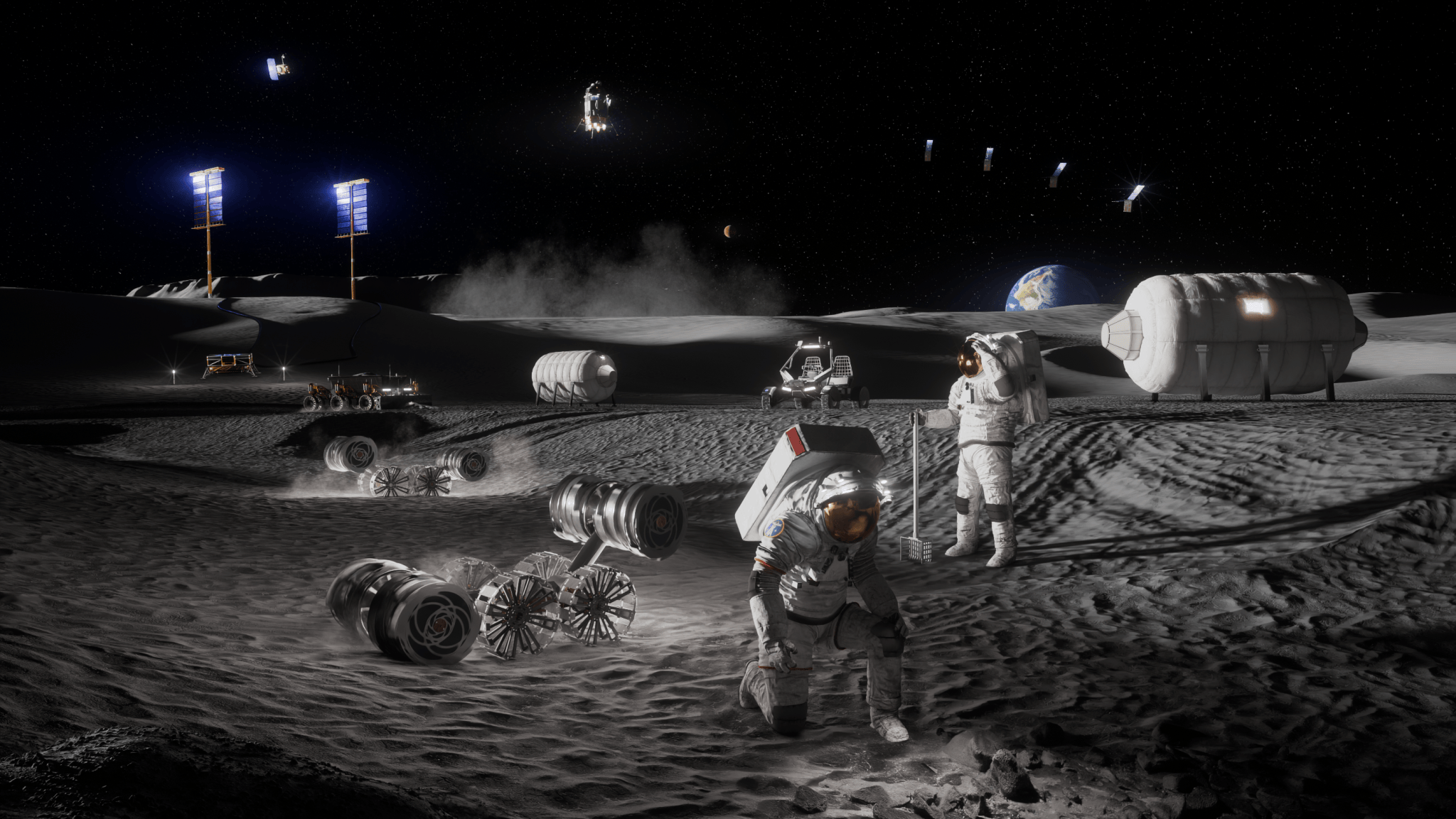
NASA Announces $1 Million to Students for Moon Base Challenge

Artist’s concept depicting astronauts, habitats, rovers, power systems, and cargo operations supporting sustained human activities at the Mo...