Wednesday, 3 June 2026

Typhoon Jangmi

A nighttime satellite image highlights the structure of a typhoon’s large eye and surrounding eyewall.

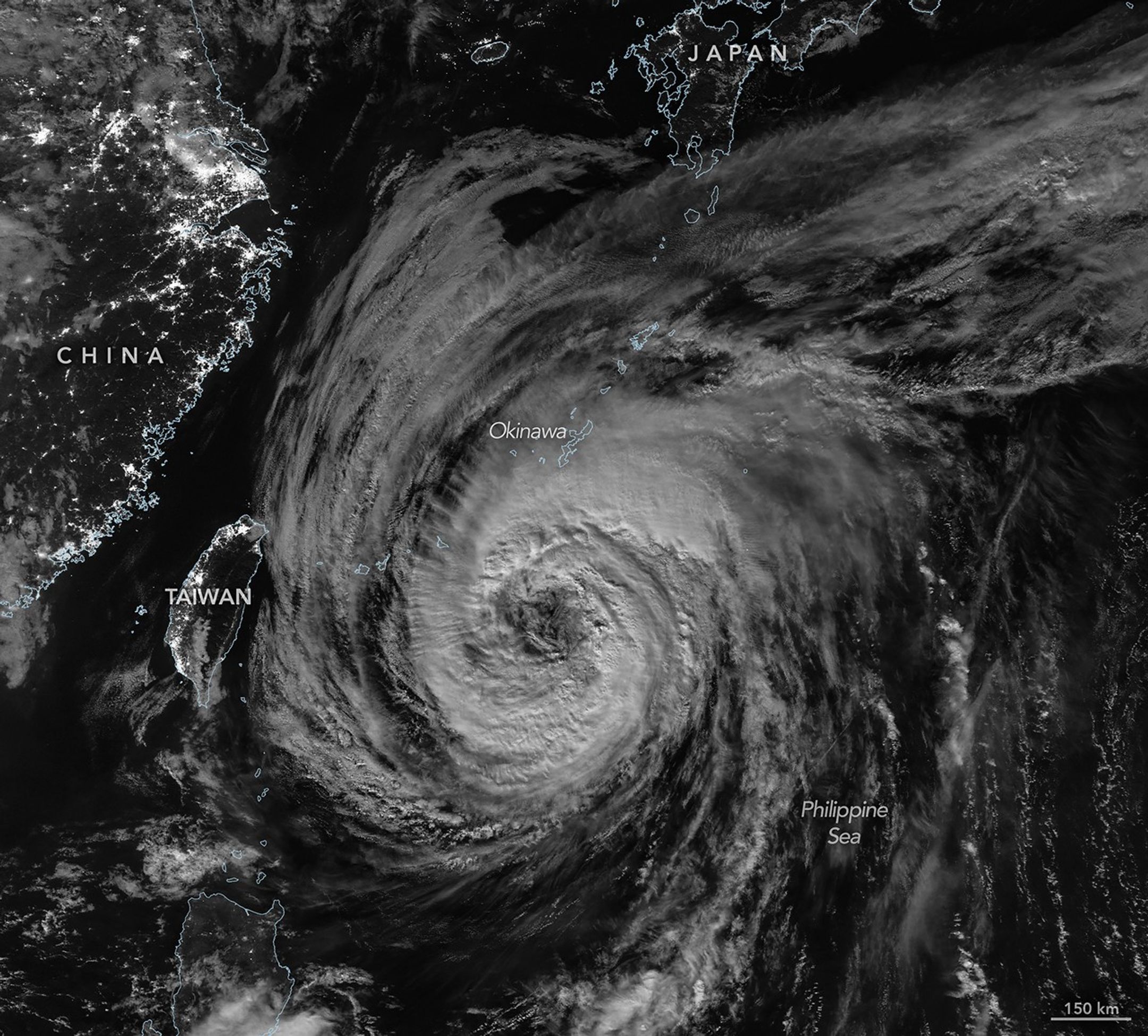
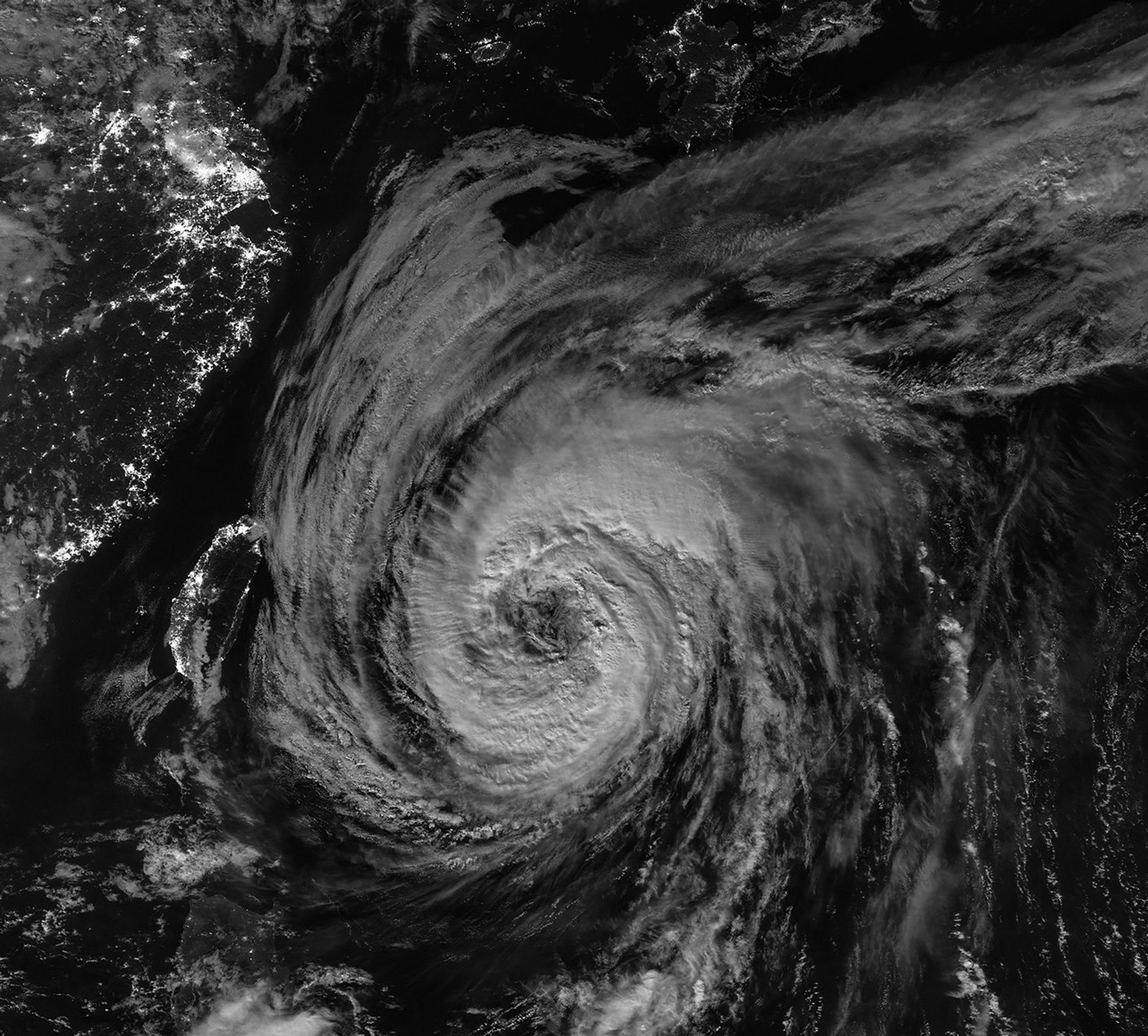
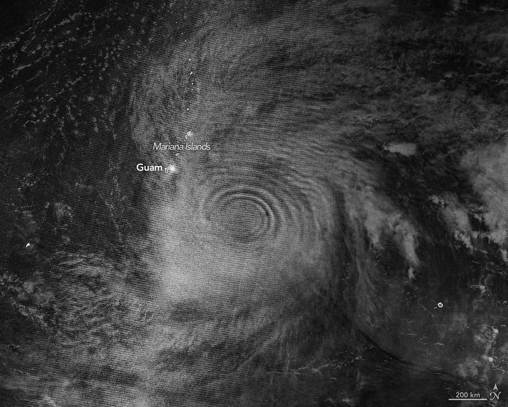
From late May into early June 2026, a broad, slow-spinning storm churned north-northwest over the Philippine Sea toward southern Japan. Typhoon Jangmi’s rainbands unleashed torrential rainfall across a vast swath of the region, triggering flooding concerns in several areas.

The VIIRS (Visible Infrared Imaging Radiometer Suite) on the Suomi NPP satellite captured this nighttime image (above) of the storm at about 16:40 Universal Time on May 30 (1:40 a.m. Japan Standard Time on May 31). Around that time, the typhoon produced sustained winds of 120 kilometers (75 miles) per hour, based on 1-minute averages reported by the Joint Typhoon Warning Center (JTWC). That’s equivalent to a category 1 storm on the Saffir-Simpson hurricane wind scale.

The image shows a detailed view of the eyewall and eye, with a diameter that is on the larger end of the spectrum, according to Scott Braun, a research meteorologist at NASA’s Goddard Space Flight Center. There also appears to be some low-level rotation on the eastern side of the eye, producing features known as “mesocyclones” that are partially obscured by high-level clouds. Though they appear striking, the features are fairly typical, Braun noted.

A nighttime satellite image shows a wide view of the typhoon with its outer cloud bands extending over southern Japan.

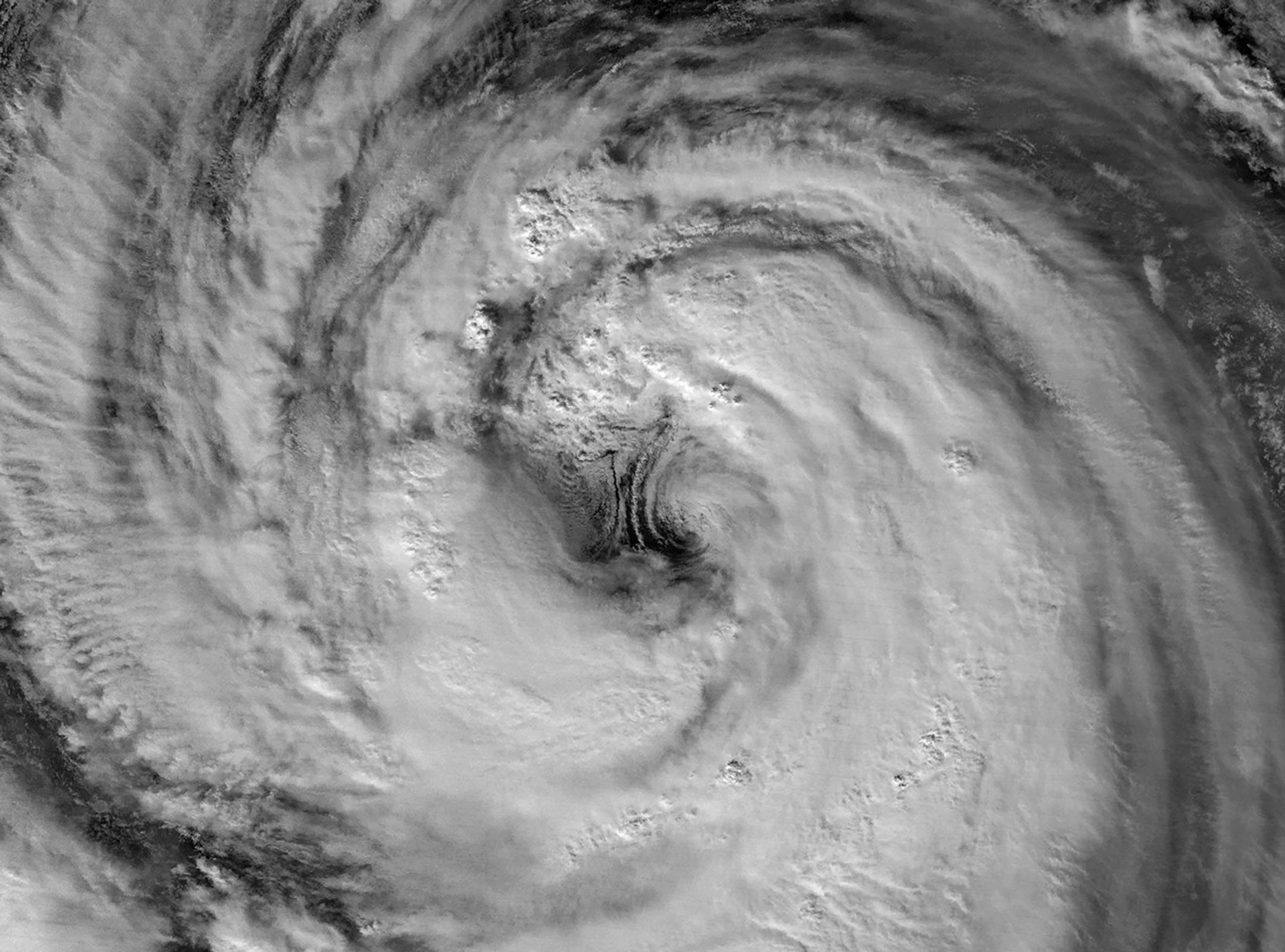
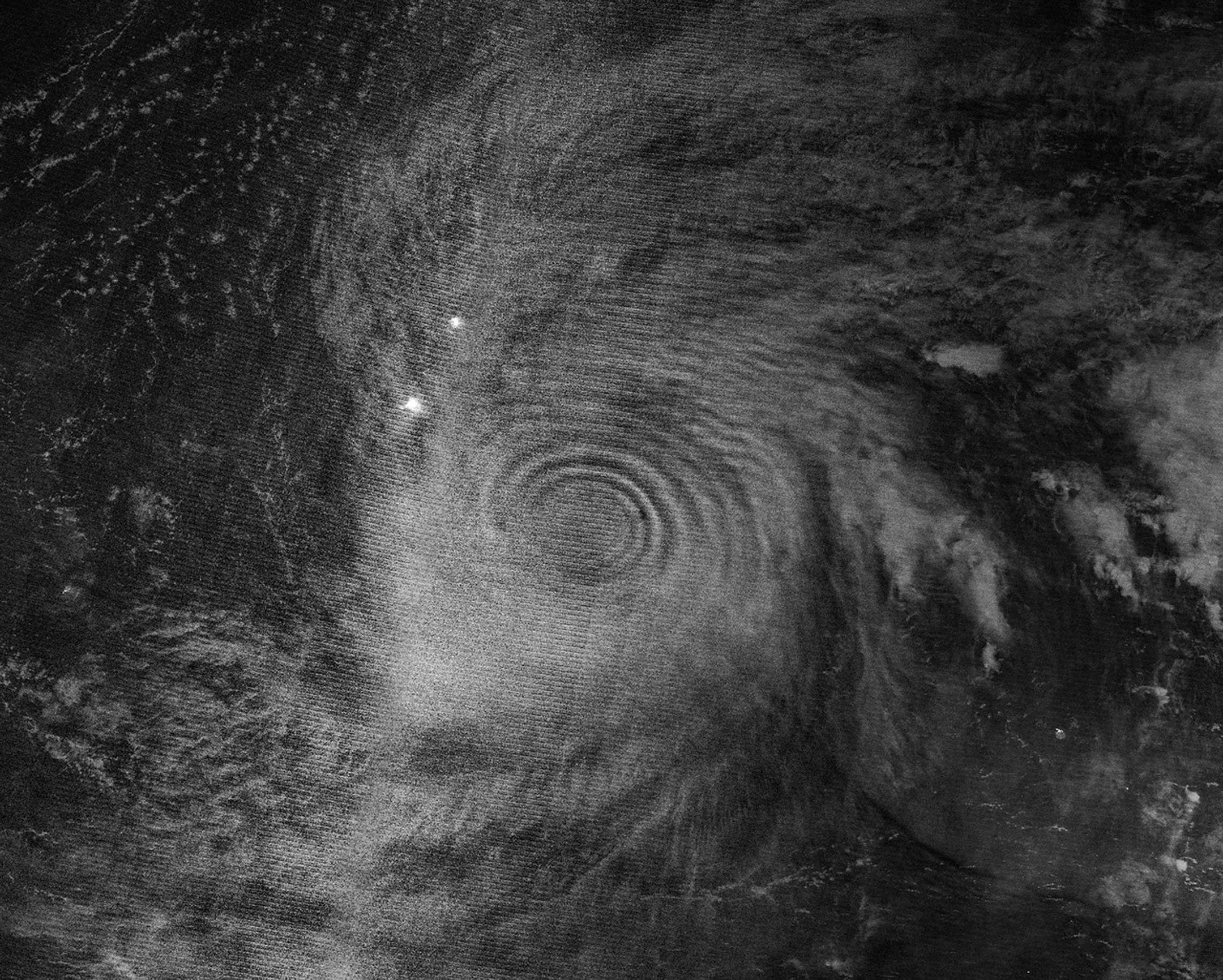
The second image shows a wider view of the same storm one day later. The VIIRS on the NOAA-20 satellite acquired this image at about 16:40 Universal Time on May 31 (1:40 a.m. Japan Standard Time on June 1), when the storm was a slightly stronger typhoon with sustained winds of 130 kilometers (80 miles) per hour.

In both images, Jangmi’s eye was still located south of Okinawa. However, the storm’s outer cloud bands already reached over land as the storm moved north. Forecasts called for the storm to make a close approach to Okinawa and then turn northeast toward the Amami region around June 1-2. It was expected to continue delivering large amounts of rain, especially along the nation’s Pacific coast, according to news reports.

NASA Earth Observatory images by Michala Garrison, using VIIRS day-night band data from NASA EOSDIS LANCEGIBS/Worldview, and the Joint Polar Satellite System (JPSS). Story by Kathryn Hansen.

Downloads

A nighttime satellite image highlights the structure of a typhoon’s large eye and surrounding eyewall.

May 30, 2026

JPEG (1.56 MB)

A nighttime satellite image shows a wide view of the typhoon with its outer cloud bands extending over southern Japan.

May 31, 2026

JPEG (2.48 MB)

References & Resources

You may also be interested in:

Stay up-to-date with the latest content from NASA as we explore the universe and discover more about our home planet.

Super Typhoon Sinlaku

3 min read

The violent storm aimed at the U.S. Northern Mariana Islands and Guam in mid-April 2026.

Article

Gravity Waves From Super Typhoon Sinlaku

4 min read

Satellites observed striking upper-atmosphere phenomena generated by an intensifying tropical cyclone.

Article

Tropical Cyclone Narelle Crosses Australia

3 min read

The powerful storm lashed the northern edge of the continent with damaging winds and drenching rain as it made landfall…

Article


from NASA https://ift.tt/YZSd08Q

NASA Space Roboticist Challenge

Fly Foundational Robots (FFR) mission
Image Credit: Motiv Space Systems

The Fly Foundational Robots (FFR) mission will launch a robotic arm, with seven degrees of freedom, to low Earth orbit. NASA is opening access to the robotic arm to a select group of U.S. researchers — principal investigators, post-doctoral researchers, professors, and highly qualified graduate students — who have a compelling experiment and the capability to execute it.

All participants must submit eligibility documentation at registration. Once your eligibility is reviewed and confirmed, you will receive access to the Phase 1 submission portal.

  • Phase 0 — Eligibility Registration
    Begin by completing your eligibility registration. Submission documentation is required at this stage as part of federal competition requirements. Registration closes at 12:59 p.m. ET (11:59 p.m. CT) on Sept. 23.
  • Phase 1 — White Paper Submission
    Submit a white paper proposing a short, focused experiment using the FFR robotic arm. Up to 15 teams advance to Phase 2. Submission closes at 12:59 p.m. ET (11:59 p.m. CT) on Oct. 2.
  • Phase 2 — Simulation & Validation
    Invited participants conduct simulation and validation testing, including visits to Goddard Space Flight Center in Greenbelt, Maryland.

Prize: Teams that pass validation will receive an offer of on-orbit experiment time on the FFR Mission

Challenge Registration Open Date: May 20, 2026

Challenge Registration Close Date: September 23, 2026

For more information, visit: https://spaceroboticistchallenge.com/


from NASA https://ift.tt/XVNFPza

Tuesday, 2 June 2026

NASA Awards Modification Contract for Reduced Gravity Test Aircraft

1 min read

Preparations for Next Moonwalk Simulations Underway (and Underwater)

NASA meatball
NASA

NASA selected Denmar Technical Services of Nevada to provide aircraft modifications, maintenance, and testing services to the Human Spaceflight Mission Directorate at NASA’s Armstrong Flight Research Center in Edwards, California, and Johnson Space Center in Houston.

The award is a firm-fixed-price contract and will be time and material for any over and above and unforeseen work. This contract has a maximum potential value of $8.4 million, which runs through Feb. 1, 2027.

The contractor will modify a Boeing 737-700 aircraft to perform lunar-gravity parabolic flights to test NASA space equipment. Once modifications are complete, NASA Armstrong will own the aircraft and oversee aircraft operations out of NASA Johnson.

The aircraft will be used to validate astronaut lunar suits and associated crew systems required to support Artemis mission objectives. This can be done with the modified 737 aircraft in an operationally relevant, reduced-gravity environment prior to lunar mission execution.

For information about NASA and agency programs, visit:

https://www.nasa.gov

-end-

Dede Dinius
Armstrong Flight Research Center, Edwards, Calif.
661-276-5701
darin.l.dinius@nasa.gov

Share

Details

Last Updated
Jun 01, 2026


from NASA https://ift.tt/TsXho7x

NASA Invites Media to See Roman Space Telescope Arrive at Kennedy

The Roman observatory in a clean room
NASA’s Nancy Grace Roman Space Telescope stands complete in the largest clean room at the agency’s Goddard Space Flight Center in Greenbelt, Maryland. With its deep, sweeping views of the universe, Roman will observe billions of cosmic objects to explore fundamental questions about dark energy and planets outside our solar system.
Credit: NASA/Scott Wiessinger

Registration is open for media to cover the arrival of NASA’s Nancy Grace Roman Space Telescope at the agency’s Kennedy Space Center in Florida in the coming weeks.

The observatory will arrive aboard NASA’s Pegasus barge from NASA’s Goddard Space Flight Center in Greenbelt, Maryland, where teams completed its construction, assembly, and testing. Credentialed media will be able to witness the arrival and unloading of the space telescope in its transport container at NASA Kennedy’s turn basin. From there, technicians will move the telescope to the center’s Payload Hazardous Servicing Facility for launch processing.

NASA subject matter experts will be available on site to answer questions about the arrival.

Media interested in participating must apply for credentials at:

https://media.ksc.nasa.gov

To receive credentials, media must apply by 11:59 p.m. EDT on Thursday, June 4. This opportunity is open to U.S. citizens only.

Once approved, credentialed media will receive a confirmation email. Additional information, including the specific date of arrival activities, will follow. NASA’s media accreditation policy is available online. For questions about accreditation, please email ksc-media-accreditat@mail.nasa.gov. For other questions, please contact Kennedy’s newsroom at: 321-867-2468.

Named after NASA’s first chief astronomer, the Nancy Grace Roman Space Telescope will have a deep, panoramic view of the cosmos, generating never-before-seen pictures that will revolutionize our understanding of the universe. The observatory will usher in a new era of cosmic surveys, unveiling troves of celestial objects, and shedding light on some of the universe’s most profound mysteries, including phenomena we can’t see. Roman also will showcase a test of the most advanced technology ever flown in space to directly image planets around nearby stars, a key step in NASA’s search for life on other worlds.

The Roman telescope is managed at NASA Goddard with participation by NASA’s Jet Propulsion Laboratory in Southern California; Caltech/IPAC in Pasadena, California; the Space Telescope Science Institute in Baltimore; and a science team of scientists from various research institutions. The primary industrial partners are BAE Systems Inc., L3Harris Technologies, and Teledyne Scientific & Imaging. Contributions to Roman also are made by ESA (European Space Agency), JAXA (Japan Aerospace Exploration Agency), the French space agency CNES (Centre National d’Études Spatiales), and the Max Planck Institute for Astronomy in Germany.

The agency’s Launch Services Program, based at NASA Kennedy, manages the launch service for the Roman Space Telescope, which will lift off as soon as early September on a SpaceX Falcon Heavy rocket from Launch Complex 39A.

For more information about NASA’s Roman telescope, visit:

https://www.nasa.gov/roman

-end-

Karen Fox / Alise Fisher
Headquarters, Washington
202-385-1287 / 202-358-2546
karen.c.fox@nasa.gov / alise.m.fisher@nasa.gov

Leejay Lockhart / Danielle Sempsrott
Kennedy Space Center, Fla.
321-747-8310 / 321-298-8990
leejay.lockhart@nasa.gov / danielle.c.sempsrott@nasa.gov

Claire Andreoli
Goddard Space Flight Center, Greenbelt, Md.
301-286-1940
claire.andreoli@nasa.gov


from NASA https://ift.tt/K3YcyCs

What’s Up: June 2026 Skywatching Tips from NASA

Venus and Jupiter meet after sunset, the Moon passes in front of Venus, summer begins, and deep-sky treasures rise into view.

Skywatching Highlights

  • June 9: Venus and Jupiter conjunction
  • June 11–15: Mercury joins Venus and Jupiter after sunset
  • June 17: Moon passes in front of Venus &  close Moon and Venus pairing
  • June 21: June solstice &  start of astronomical summer
  • June: Summer Triangle and deep-sky observing targets rise into view

Transcript

Planets gather after sunset, the Moon passes in front of Venus, summer officially begins and deep sky treasures rise into view. That’s What’s Up for June.

Early this month, look west shortly after sunset to see Venus and Jupiter. They are two of the brightest planets in our sky and around June 9th, they’ll appear close together after sunset. This is called a planetary conjunction—when two planets appear near each other from our point of view on Earth, even though they’re still millions of miles apart in space.

Sky chart showing the western sky around 9pm on June 9, 2026, with Venus and Jupiter in very close conjunction near the horizon, Mercury visible to their lower right, and the stars Regulus, Pollux, Procyon, and Capella also labeled.
NASA/JPL-Caltech

From June 11th through June 15th, Mercury joins the scene, creating a mini parade of planets low in the western sky. This happens because the planets orbit the sun along nearly the same path in our sky, called the ecliptic. So from our point of view on Earth, they sometimes appear to gather in the same part of the sky.

Sky chart showing the western sky around 9pm on June 14, 2026, with Venus and Jupiter appearing close together near the horizon, Mercury to their lower right, and the stars Regulus, Pollux, Procyon, and Capella also visible.
NASA/JPL-Caltech

Venus will be the brightest and easiest to spot with Jupiter nearby. Mercury will sit lower toward the horizon, so you will need a clear view to the west to catch it in the glow of twilight.

On June 17th, from some locations the Moon will pass in front of Venus. This is called a lunar occultation. For viewers in the right viewing path, Venus will look like it disappears behind the Moon, then reappears later. The event will be visible from parts of the United States, Canada, Brazil and Venezuela. Outside of the exact viewing path, many skywatchers may still see a close pairing of the Moon and Venus, but this comes with an important safety note. For many viewers this will happen during the daytime.

If you’re trying to observe the occultation, do not point binoculars, a telescope, or a camera near the sun unless you’re using proper solar safety equipment. Looking at or near the sun through optics can cause serious eye injury.

June also brings the summer solstice. In the Northern Hemisphere, the June solstice marks the start of the astronomical summer. In Pacific time, it happens on Sunday, June 21st at 1:24 a.m.

Around the solstice, the Northern Hemisphere gets its longest days and shortest nights of the year.

But here’s a fun fact, the longest day does not usually line up exactly with the earliest sunrise or latest sunset. For example, in Los Angeles, the earliest sunrise comes before the solstice, while the latest sunset comes after it.

And once the sky gets dark, summer brings some favorite targets for telescope users and astrophotographers. First, look for the Summer Triangle, formed by the bright stars Vega, Altair, and Deneb. Inside and around this region are deep sky objects like the Dumbbell Nebula, the Ring Nebula, the North America Nebula, and the Veil Nebula. The Dumbbell Nebula, also known as Messier 27, was the first planetary nebula ever discovered.

These objects are not bright like planets, but with telescopes or long exposure photography, they reveal glowing gas, dying stars, and stellar nurseries in our galaxy.

Star chart showing the Summer Triangle asterism in the eastern sky during summer evenings after sunset, with its three vertices labeled Vega (top), Deneb (left), and Altair (right).
NASA/JPL-Caltech

Here are the phases of the Moon for June. You can stay up to date on all of NASA’s missions exploring the solar system and beyond at science.nasa.gov. I’m Raquel Villanueva from NASA’s Jet Propulsion Laboratory, and that’s What’s Up this month.

Chart showing June 2026 moon phases: Third Quarter on the 8th, New Moon on the 14th, First Quarter on the 21st, and Full Moon on the 29th.
NASA/JPL-Caltech


from NASA https://ift.tt/vJUnqto

NASA to Conduct Low-Altitude Flights Near Houston 

NASA’s C-20A research aircraft takes off from the Edwards Air Force Base runway on an envelope-expansion flight test with the unmanned aerial vehicle synthetic aperture radar pod.
NASA/Tony Landis

Five research aircraft will support a Student Airborne Research Program (SARP) mission out of Ellington Field in Houston. Flights are expected from Wednesday, June 3 to Saturday, June 13. During the mission, select maneuvers will be conducted at low altitudes over the Houston area. 

Pilots will fly remote sensing payloads in raster patterns, or parallel back-and-forth lines. The instruments flown could help researchers map the movement of the gases and particles that make up Earth’s atmosphere, changes to the lowest part of the atmosphere near the coastline, and the natural processes affecting the land and water in that area. The flights will primarily take place in the Houston area, with some extending over the Gulf of America.  

While many of the flights will operate at higher altitudes, a WP-3D Orion will conduct maneuvers as low as 1,000 feet above ground level. Owned and operated by the National Oceanic and Atmospheric Administration (NOAA), this aircraft is used as a hurricane hunter and has supported several airborne science missions for NASA. It is equipped with a multitude of scientific instrumentation, radars, and recording systems for both in-flight and remote sensing measurements of the atmosphere, the Earth, and its environment. 

The NASA-operated aircraft participating in the mission also are equipped with a variety of remote sensing instruments, including two lidars, a synthetic-aperture radar, an imaging spectrometer, and two spectrometers. 

The operations will involve the agency’s Gulfstream V (N95NA), Gulfstream C-20A (N802NA), and Gulfstream III (N520NA), as well as NOAA’s WP-3D Orion (N43RF) and a King Air B200 aircraft (N46L) owned by Dynamic Aviation and contracted by NASA. The flights can be tracked in real time at NASA Airborne Science Program Tracker

The SARP effort is an eight-week summer internship program that provides undergraduate students with hands-on experience by engaging in field research and data analysis and with access to one or more NASA Airborne Science Program flying science laboratories. 

For more information about the NASA Airborne Science program, visit: 

https://airbornescience.nasa.gov


from NASA https://ift.tt/LuQ5Cbo

Monday, 1 June 2026

Pretty in Pink

Scores of gleaming stars ringed in neon pink stretch across the frame, highlighting a cluster where stars are between one and three million years old. Brick-orange dust clouds along the bottom edge illustrate the raw materials of this active stellar nursery.
X-ray: NASA/CXC/SAO/Sejong Univ./Hur et al; JWST: ESA/Webb, NASA & CSA, V. Almendros-Abad, M. Guarcello, K. Monsch, and the EWOCS team. Image Processing: NASA/CXC/SAO/L. Frattare and K. Arcand

This image of Westerlund 2 released on March 19, 2026, features Chandra X-ray Observatory data (pink) and infrared data from NASA’S James Webb Space Telescope (red, orange, green, cyan, and blue). Scores of gleaming stars ringed in neon pink stretch across the frame, highlighting a cluster where stars are between one and three million years old. Brick-orange dust clouds along the bottom edge illustrate the raw materials of this active stellar nursery.

Westerlund 2 resides in a raucous stellar breeding ground known as Gum 29, located 20,000 light-years away from Earth in the constellation Carina.

See a different view of Westerlund 2.

Image credit: X-ray: NASA/CXC/SAO/Sejong Univ./Hur et al; JWST: ESA/Webb, NASA & CSA, V. Almendros-Abad, M. Guarcello, K. Monsch, and the EWOCS team. Image Processing: NASA/CXC/SAO/L. Frattare and K. Arcand


from NASA https://ift.tt/SK4o8rG

Gravity Waves From Super Typhoon Sinlaku

Gravity waves in the upper atmosphere appear as concentric rings in a nighttime, black and white satellite image. Clouds from a typhoon are also visible.
Atmospheric gravity waves generated by Super Typhoon Sinlaku are visible via mesospheric airglow in this nighttime image acquired with the VIIRS (Visible Infrared Imaging Radiometer Suite) on the NOAA-20 satellite on April 12, 2026, Universal Time (April 13 local time).
NASA Earth Observatory/Michala Garrison

In mid-April 2026, Super Typhoon Sinlaku churned across the North Pacific Ocean and brought heavy rain and flooding to the Mariana Islands. The storm reached “violent typhoon” status—the highest intensity on the scale used by the Japan Meteorological Agency and roughly equivalent to a category 5 storm on the Saffir-Simpson wind scale. Sinlaku was one of only a handful of tropical cyclones of that intensity known to have occurred so early in the year in the region, meteorologists noted.

Sinlaku rapidly intensified over the ocean before its impacts reached land. Around the time of this strengthening, satellites began to detect that the typhoon’s effects also extended upward, into the upper atmosphere.

The nighttime image above, acquired with the VIIRS (Visible Infrared Imaging Radiometer Suite) on the NOAA-20 satellite, shows atmospheric gravity waves radiating from the typhoon. These waves, resembling ripples on a pond, were made visible to the sensor via airglow in the mesosphere. Airglow occurs when atoms and molecules, excited by sunlight during the day, later emit light to release excess energy.

The release of latent heat near the eyewalls of tropical cyclones is known to drive convection and the formation of tall cumulonimbus clouds. These “hot towers” can rise out of the troposphere, the lowest layer of the atmosphere, and generate waves that propagate into the stratosphere and mesosphere above. An analysis of past tropical cyclones revealed that gravity waves often occur around the time that storms are intensifying. Indeed, in the 24 hours prior to the acquisition of the image above, Sinlaku had strengthened from a category 2 to a category 5 storm.

“We’re seeing waves propagating radially and upward, in a cone-like shape,” said Joan Alexander, senior research scientist at NorthWest Research Associates. Alexander was surprised to see well-defined waves in the mesospheric airglow above the storm. Winds in the upper atmosphere can dissipate the waves before they reach such high altitudes, Alexander explained, but relatively light stratospheric winds at the storm’s latitude in April 2026 may have helped preserve them.

A relatively low amount of moonlight was fortuitous, as well. The VIIRS day-night band is sensitive to airglow in the mesosphere but also observes reflected moonlight. The Moon was about 25 percent illuminated on April 12, so some light reflected off clouds in the troposphere was visible, but not enough to overpower the signal from the airglow.

The signature of gravity waves in the stratosphere appears as concentric rings in infrared satellite data.
Thermal energy from gravity waves produced by Super Typhoon Sinlaku was detected in the stratosphere by the AIRS (Atmospheric Infrared Sounder) instrument on NASA’s Aqua satellite on April 13, 2026.
NASA Earth Observatory/Michala Garrison

Sinlaku’s gravity waves, in addition to appearing high in the atmosphere via airglow, were observed lower in the atmosphere by the AIRS (Atmospheric Infrared Sounder) instrument on NASA’s Aqua satellite. The image above depicts thermal emissions from gravity waves in the stratosphere on April 13. The rippling pattern appeared in April 14 observations, as well, indicating the storm’s continuing effects on the atmosphere.

Observing atmospheric gravity waves, particularly those caused by tropical cyclones, goes beyond scientific curiosity. Practical implications could include improved monitoring of storm development. “We’d like to use gravity waves to tell us if a storm is intensifying,” Alexander said, “which can be difficult to know, especially over the open ocean.” A geostationary satellite with the proper infrared imager would be able to observe gravity waves and track tropical cyclone evolution, she and colleagues have argued.

Furthermore, it’s critical to account for processes in the stratosphere in weather models, said Laura Holt, also a senior research scientist at NorthWest Research Associates. Stratospheric wind patterns are factors in long-term forecasts of the next Northern Hemisphere winter, for example, and tropical cyclones have a disproportionate influence because their sustained, intense convection drives prolonged gravity wave forcing of the stratosphere.

The effect of gravity waves even reaches into the realm of space weather. “For a while, people have seen signatures of hurricanes in ionospheric weather,” Holt said. Gravity waves can lead to traveling ionospheric disturbances—large-scale ripples in plasma density—and in some cases plasma bubbles, both of which can disrupt satellite signals and radio communications. “With space weather in particular,” Holt added, “a single event such as a tropical cyclone can be very important.”

NASA Earth Observatory images by Michala Garrison, using VIIRS day-night band data from NASA EOSDIS LANCE, GIBS/Worldview, and the Joint Polar Satellite System (JPSS), and AIRS data from Hoffmann, L. Story by Lindsey Doermann.

Downloads

Gravity waves in the upper atmosphere appear as concentric rings in a nighttime, black and white satellite image. Clouds from a typhoon are also visible.

VIIRS: April 12, 2026

JPEG (2.89 MB)

The signature of gravity waves in the stratosphere appears as concentric rings in infrared satellite data.

AIRS: April 13, 2026

JPEG (1.75 MB)

References & Resources

Hoffmann, L., et al. (2018) Satellite observations of stratospheric gravity waves associated with the intensification of tropical cyclones. Geophysical Research Letters, 45, 1692–1700. 

NASA (2018, October 22) Why NASA Watches Airglow, the Colors of the (Upper Atmospheric) Wind. Accessed May 28, 2026.

NASA Earth Observatory (2026, April 14) Super Typhoon Sinlaku. Accessed May 28, 2026.

Nolan, D. S. (2020) An Investigation of Spiral Gravity Waves Radiating from Tropical Cyclones Using a Linear, Nonhydrostatic ModelJournal of the Atmospheric Sciences, 77, 1733–1759.

You may also be interested in:

Stay up-to-date with the latest content from NASA as we explore the universe and discover more about our home planet.

Super Typhoon Sinlaku

3 min read

The violent storm aimed at the U.S. Northern Mariana Islands and Guam in mid-April 2026.

Article

Tropical Cyclone Narelle Crosses Australia

3 min read

The powerful storm lashed the northern edge of the continent with damaging winds and drenching rain as it made landfall…

Article

A Second Cyclone Slams Madagascar

3 min read

Widespread flooding affected tens of thousands of people after cyclones Fytia and Gezani drenched the island.

Article


from NASA https://ift.tt/jvs2Rp3

La NASA adjudica nuevas misiones científicas para Base Lunar y adelanta nuevas oportunidades

Tres representaciones digitales muestran módulos de aterrizaje lunar comerciales de Astrobotic, Intuitive Machines y Firefly en la Luna. La ...