
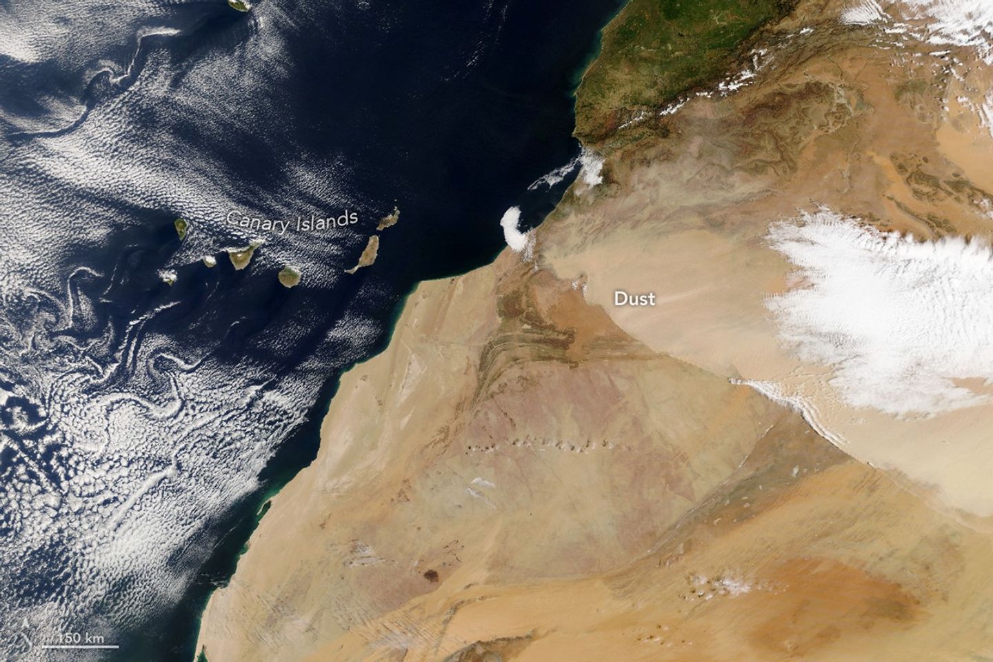
Morning
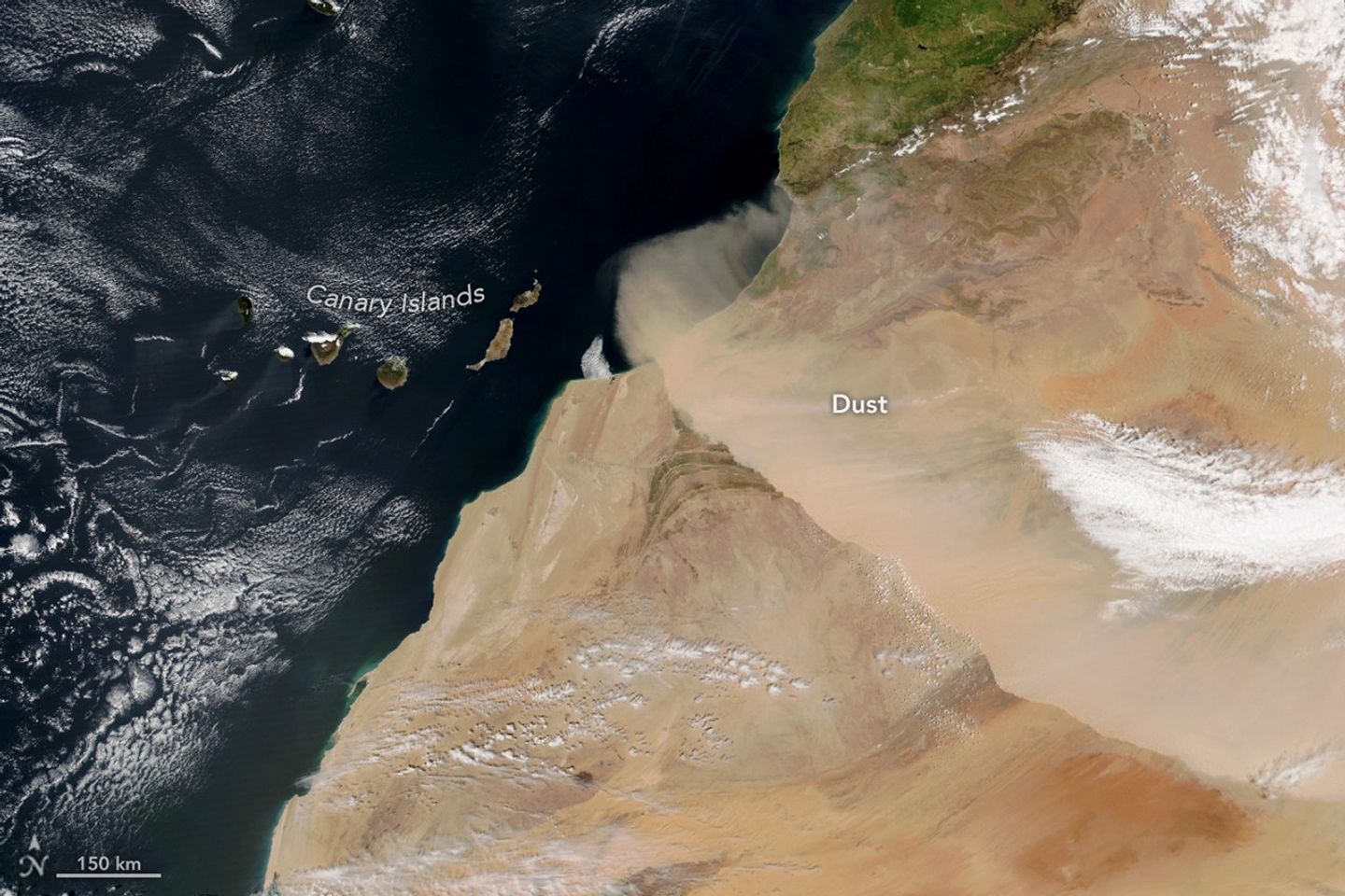
Afternoon
March 30, 2026
In early spring 2026, a dry, dust-laden wind known as the harmattan swept across northwestern Africa. Cold temperatures, high winds, and blowing dust prompted officials to issue an alert for several regions of Morocco due to the low visibility and harsh conditions.
Satellites tracked the wall of dust over the course of the day on March 30 as it moved southwest from the Sahara Desert and toward the Atlantic Ocean. The left image, captured by NASA’s Terra satellite, shows the dust at about 10:00 Universal Time (11 a.m. local time in Morocco). The NOAA-21 satellite captured the right image about four hours later.
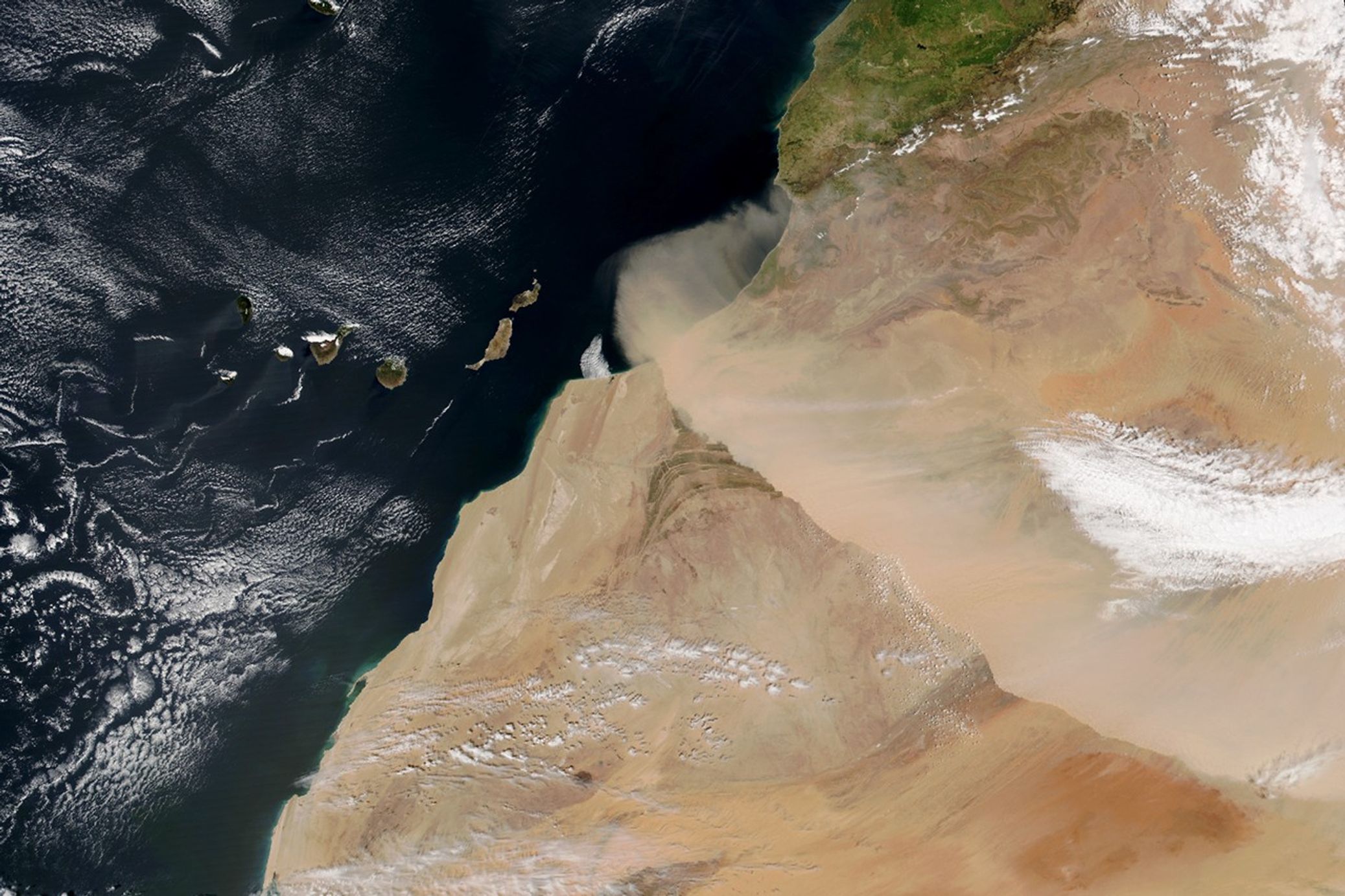
Meteosat-12, a satellite operated by the European Organization for the Exploitation of Meteorological Satellites (EUMETSAT), captured another view of the dust storm. The geostationary weather satellite showed the dust’s movement as it moved closer to the Canary Islands.
According to Spain’s state meteorological agency (AEMET), the harmattan winds blow from the northeast between November and April, often producing dust storms as winds lift dust particles from the Sahara. During the March 30 event, AEMET noted that conditions were right for a harmattan surge, which happens when winds get stronger near the ground with the passing of a cold front. That day, winds converged perpendicular to the High Atlas mountain range before shifting southwest.
Forecasts called for the Saharan dust to ultimately engulf the Canary Islands, triggering what islanders know as calima. The dust episode was expected to worsen air quality and visibility across the islands through April 1. A separate storm earlier in March also sent dust toward the Canaries, along with another plume that dispersed widely across Europe.
Researchers using NASA data have previously reported that the most intense Saharan dust storms occur in the spring, when dust is typically lifted from the sand seas, or ergs, of central North Africa and areas along the Mediterranean coast. In the warmer months, another peak occurs in the central Sahara.
NASA Earth Observatory images by Lauren Dauphin, using MODIS and VIIRS data from NASA EOSDIS LANCE, GIBS/Worldview, and the Joint Polar Satellite System (JPSS). Story by Kathryn Hansen.

References & Resources
- AEMET Divulga via X (2026, March 31) These satellite images show a surge of harmattan, a dust storm (haboob) generated by the harmattan wind from the region. Accessed March 31, 2026.
- CIRA Satellite Library (2026, March 30) Daily loop from: Meteosat-12. Accessed March 31, 2026.
- Fiedler, S. et al. (2015) The importance of Harmattan surges for the emission of North African dust aerosol. Geophysical Research Letters, 42 (21), 9495-9504.
- HESPRESS (2026, March 30) Morocco issues orange alert for cold weather, strong winds, and dust storms. Accessed March 31, 2026.
- NASA Earth Observatory (2026, March 12) Dust Outbreak Reaches Europe. Accessed March 31, 2026.
- Saleh, S.A. et al. (2025) A preliminary assessment of the spatial and temporal patterns of sand and dust storms over the Sahara. Scientific African, 28 (e02729).
You may also be interested in:
Stay up-to-date with the latest content from NASA as we explore the universe and discover more about our home planet.

Clouds of dust lofted from the Sahara Desert brought hazy skies and muddy rain to Western Europe.

An advancing cold front kicked up a sharp line of sand and other small particles that swept over the high…

Reed-covered mounds exposed by declining water levels reveal an unexpected network of freshwater springs that feed directly into the lake…
Discover More from NASA Earth Science
Subscribe to Earth Observatory Newsletters
Subscribe to the Earth Observatory and get the Earth in your inbox.
Earth Observatory Image of the Day
NASA’s Earth Observatory brings you the Earth, every day, with in-depth stories and stunning imagery.

Explore Earth Science

Earth Science Data
Open access to NASA’s archive of Earth science data

from NASA https://ift.tt/YsivyUo


No comments:
Post a Comment